Approximate Location Map
Large Map »
Latitude: 55.1411 / 55°8'27"N
Longitude: -1.8279 / 1°49'40"W
OS Eastings: 411070
OS Northings: 582980
OS Grid: NZ110829
Mapcode National: GBR H8PZ.2W
Mapcode Global: WHC2V.W1RM
Plus Code: 9C7W45RC+CV
Entry Name: Meldon Lane House
Listing Date: 30 January 1986
Grade: II
Source: Historic England
Source ID: 1042898
English Heritage Legacy ID: 238335
ID on this website: 101042898
Location: Northumberland, NE61
County: Northumberland
Civil Parish: Meldon
Traditional County: Northumberland
Lieutenancy Area (Ceremonial County): Northumberland
Church of England Parish: Bolam St Andrew
Church of England Diocese: Newcastle
Tagged with: House
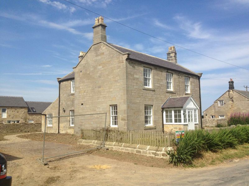
MELDON MELDON LANE
NZ 18 SW NZ 111830
15/l02 Meldon Lane House
GV II
House, c.1840. Squared stone, slate roof. T-plan, part of planned farm
layout. 2 storeys, 3 bays, symmetrical. Plinth. Central renewed door under
small C20 porch; 12-pane sash windows with slightly projecting sills. All
openings have chamfered surrounds. Coped gables with moulded kneelers, stepped
and corniced end stacks.
Listing NGR: NZ1107082980
External links are from the relevant listing authority and, where applicable, Wikidata. Wikidata IDs may be related buildings as well as this specific building. If you want to add or update a link, you will need to do so by editing the Wikidata entry.


Other nearby listed buildings
