Approximate Location Map
Large Map »
Latitude: 54.8188 / 54°49'7"N
Longitude: -2.2636 / 2°15'48"W
OS Eastings: 383160
OS Northings: 547132
OS Grid: NY831471
Mapcode National: GBR DDMQ.RD
Mapcode Global: WHB32.64CP
Plus Code: 9C6VRP9P+GH
Entry Name: Adit Entrance of Swinhope Horse Level on South Bank of Swinhope Burn
Listing Date: 23 August 1985
Grade: II
Source: Historic England
Source ID: 1042934
English Heritage Legacy ID: 240286
ID on this website: 101042934
Location: Northumberland, NE47
County: Northumberland
Civil Parish: Allendale
Traditional County: Northumberland
Lieutenancy Area (Ceremonial County): Northumberland
Church of England Parish: Allendale St Cuthbert
Church of England Diocese: Newcastle
Tagged with: Building
NY 84 NW LANDS COMMON TO THE SWIN HOPE
PARISHES OF ALLENDALE
AND WEST ALLEN
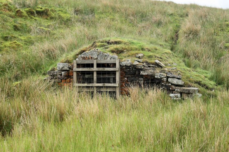
21/166 Adit entrance of Swinhope
Horse Level on south bank
of Swinhope Burn
II
Lead mine adit portal. Early C19. Squared rubble. Section of walling with
elliptical-arched adit portal and square locker to right. Immediately within
portal, similar lockers, probably for miners' lamps, on left and right of
passage. Swinhope Mine was in operation 1815-1872. The horse level was driven
to link up with the earlier Whimsey Shaft, working the Swinhope or Williams
Vein.
Listing NGR: NY8316047132
External links are from the relevant listing authority and, where applicable, Wikidata. Wikidata IDs may be related buildings as well as this specific building. If you want to add or update a link, you will need to do so by editing the Wikidata entry.


Other nearby listed buildings
