Approximate Location Map
Large Map »
Latitude: 54.8427 / 54°50'33"N
Longitude: -2.2389 / 2°14'20"W
OS Eastings: 384755
OS Northings: 549790
OS Grid: NY847497
Mapcode National: GBR DDTF.2T
Mapcode Global: WHB2W.LJ2W
Plus Code: 9C6VRQV6+3C
Entry Name: Powder House in Field 150 Metres South of Sipton Terrace
Listing Date: 23 August 1985
Grade: II
Source: Historic England
Source ID: 1042948
English Heritage Legacy ID: 240220
ID on this website: 101042948
Location: Spartylea, Northumberland, NE47
County: Northumberland
Civil Parish: Allendale
Traditional County: Northumberland
Lieutenancy Area (Ceremonial County): Northumberland
Church of England Parish: Allendale St Cuthbert
Church of England Diocese: Newcastle
Tagged with: Building
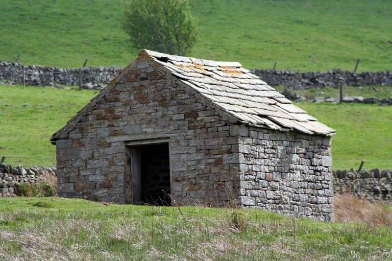
NY 84 NW ALLENDALE SIPTON
21/100 Powder House in field
150 metres south of
Sipton Terrace
II
Powder House for lead mine, C19. Squared stone, stone slate roof. Small
square structure with gabled roof, divided by an internal stone wall into
two unequal compartments. Door in each gable, larger northern compartment
with simple board panelling.
Listing NGR: NY8475549790
External links are from the relevant listing authority and, where applicable, Wikidata. Wikidata IDs may be related buildings as well as this specific building. If you want to add or update a link, you will need to do so by editing the Wikidata entry.


Other nearby listed buildings
