Approximate Location Map
Large Map »
Latitude: 50.8561 / 50°51'22"N
Longitude: 0.5953 / 0°35'43"E
OS Eastings: 582764
OS Northings: 109501
OS Grid: TQ827095
Mapcode National: GBR QYP.7B5
Mapcode Global: FRA D64T.V2J
Plus Code: 9F22VH4W+F4
Entry Name: Hastings Fishermen's Museum
Listing Date: 14 September 1976
Grade: II
Source: Historic England
Source ID: 1043428
English Heritage Legacy ID: 294063
ID on this website: 101043428
Location: Old Town, Hastings, East Sussex, TN34
County: East Sussex
District: Hastings
Electoral Ward/Division: Old Hastings
Parish: Non Civil Parish
Built-Up Area: Hastings
Traditional County: Sussex
Lieutenancy Area (Ceremonial County): East Sussex
Church of England Parish: Hastings St Clement and All Saints
Church of England Diocese: Chichester
Tagged with: Maritime museum Independent museum
This list entry was subject to a Minor Amendment on 28/02/2018
TQ 8209 SE 15/486
TQ 8209 SE 8/485
ROCK-A-NORE ROAD (South Side)
No 21, Hastings Fishermen's Museum
(Formerly listed as Fishermen's Museum, ROCK-A-NORE ROAD)
II
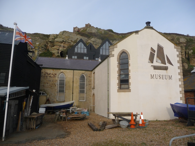
1854. Built as Fishermen's Church now a museum. Plain. Coursed stone, stuccoed south, east and west walls, exposed masonry on north wall with stuccoed quoins. Low-pitched slated roof with coped gable ends, east end with stone cross at apex and west end with bellcote. North and south walls have tall lancets, south wall with later lean-to vestry. East and west ends have tripartite lancets, taller at centre. Four-centred arch doorway at west end of north and south walls. No division between nave and chancel. Gallery across the west end.
Listing NGR: TQ8276409501
External links are from the relevant listing authority and, where applicable, Wikidata. Wikidata IDs may be related buildings as well as this specific building. If you want to add or update a link, you will need to do so by editing the Wikidata entry.


Other nearby listed buildings
