Approximate Location Map
Large Map »
Latitude: 50.8691 / 50°52'8"N
Longitude: 0.0065 / 0°0'23"E
OS Eastings: 541287
OS Northings: 109648
OS Grid: TQ412096
Mapcode National: GBR KQ2.GGJ
Mapcode Global: FRA B6XS.SG1
Plus Code: 9F22V294+JJ
Entry Name: Manning Tomb 5 Yards South East of Church of St John the Baptist
Listing Date: 29 October 1985
Grade: II
Source: Historic England
Source ID: 1043717
English Heritage Legacy ID: 293373
ID on this website: 101043717
Location: St John the Baptist's Church, Southover, Lewes, East Sussex, BN7
County: East Sussex
District: Lewes
Civil Parish: Lewes
Built-Up Area: Lewes
Traditional County: Sussex
Lieutenancy Area (Ceremonial County): East Sussex
Church of England Parish: Lewes St John the Baptist
Church of England Diocese: Chichester
Tagged with: Building
TQ 4109 NW LEWES SOUThOVER HIGH STREET
14/383 (south side)
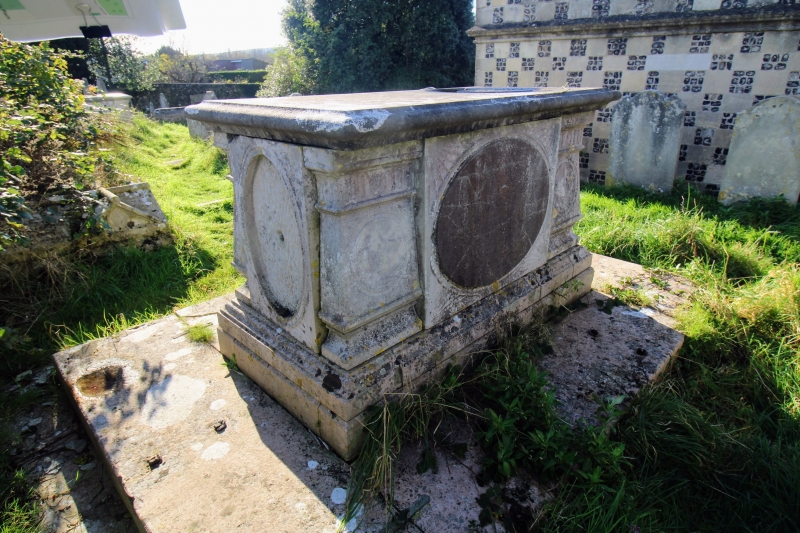
Manning tomb 5 yards south east
of Church of St John the Baptist
GV II
Chest tomb. Dated 1779. Dressed stone. Stepped base with moulded plinth.
Moulded squared tapering baluster corners with panels of vases inscribed.
Oval inscription panels to sides and ends with fan-decorated spandrels.
Corniced lid. Inscribed to......, Manning, d. 1779.
Listing NGR: TQ4128709648
External links are from the relevant listing authority and, where applicable, Wikidata. Wikidata IDs may be related buildings as well as this specific building. If you want to add or update a link, you will need to do so by editing the Wikidata entry.


Other nearby listed buildings
