Approximate Location Map
Large Map »
Latitude: 50.952 / 50°57'7"N
Longitude: 0.7353 / 0°44'7"E
OS Eastings: 592219
OS Northings: 120511
OS Grid: TQ922205
Mapcode National: GBR RZ1.6Q6
Mapcode Global: FRA D6FL.G98
Plus Code: 9F22XP2P+Q4
Entry Name: St Andrews and Part of Cap Griz Nez
Listing Date: 11 September 1972
Grade: II
Source: Historic England
Source ID: 1044308
English Heritage Legacy ID: 291947
ID on this website: 101044308
Location: Rye, Rother, East Sussex, TN31
County: East Sussex
District: Rother
Civil Parish: Rye
Built-Up Area: Rye
Traditional County: Sussex
Lieutenancy Area (Ceremonial County): East Sussex
Church of England Parish: Rye
Church of England Diocese: Chichester
Tagged with: Building
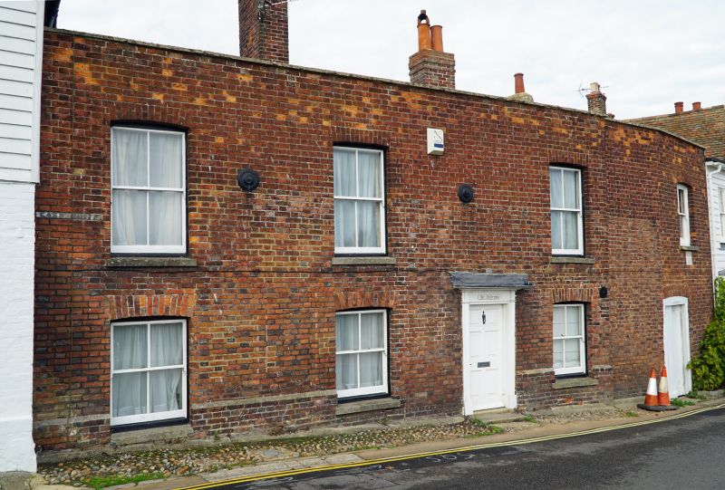
1.
1578 EAST CLIFF
(West Side)
St Andrews and part of
Cap Griz Nez
TQ 9220 1/95
II
2.
Formerly shown only as St Andrews.
C18. 2 storeys, the ground floor being below the level of the road. 3
windows. Red brick. Parapet. Glazing bars missing. Doorway with thin
pilasters and small flat hood. There is an eastern extension which now
belongs to the next house (Cap Gris Nez) but is continuous with St Andrews
and identical in appearance; although built in 1903. 1 window with doorway
underneath.
Listing NGR: TQ9221620511
External links are from the relevant listing authority and, where applicable, Wikidata. Wikidata IDs may be related buildings as well as this specific building. If you want to add or update a link, you will need to do so by editing the Wikidata entry.


Other nearby listed buildings
