Latitude: 51.1855 / 51°11'7"N
Longitude: -0.6156 / 0°36'56"W
OS Eastings: 496854
OS Northings: 143826
OS Grid: SU968438
Mapcode National: GBR FD2.M5N
Mapcode Global: VHFVT.8GYK
Plus Code: 9C3X59PM+5Q
Entry Name: The Pepper Pot
Listing Date: 18 December 1947
Last Amended: 1 February 1991
Grade: II
Source: Historic England
Source ID: 1044496
English Heritage Legacy ID: 291415
ID on this website: 101044496
Location: Godalming, Waverley, Surrey, GU7
County: Surrey
District: Waverley
Civil Parish: Godalming
Built-Up Area: Godalming
Traditional County: Surrey
Lieutenancy Area (Ceremonial County): Surrey
Church of England Parish: Godalming
Church of England Diocese: Guildford
Tagged with: Building
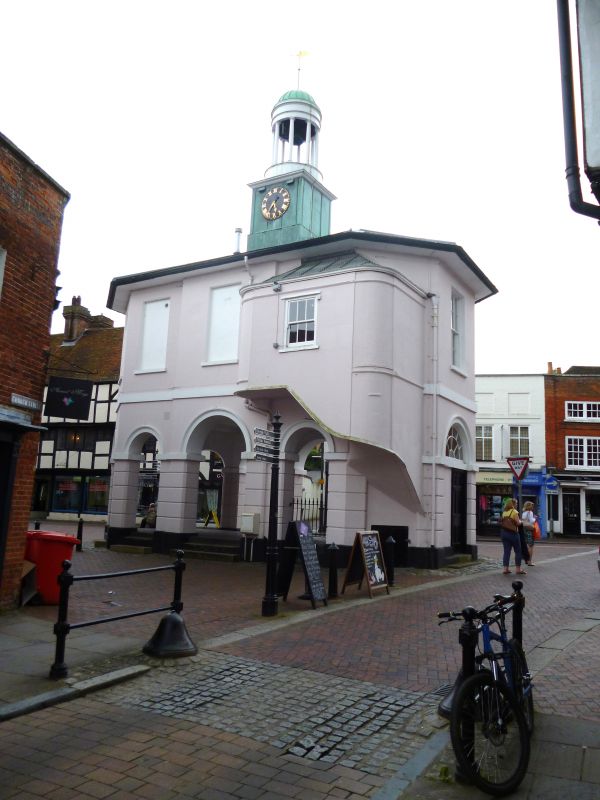
GODALMING HIGH STREET
SU 9643 NE
(north side)
12/136
The Pepper Pot (formerly
18.12.47 listed as Town Hall)
GV
II
Former Town Hall. Dated 1814, by John Perry; stair tower added 1890s. Stuccoed
with Welsh slate roof. 2 storeys, the lower storey open. 3 x 3 bays, the
shorter sides canted and so forming elongated octagonal plan. South elevation:
projecting central bay. On ground floor, round-arched arcade with rusticated
columns on plinths, imposts and archivolts, the central arch larger. First
floor: band, broken in centre by date plaque; 3 sashes with glazing bars in
reveals with projecting sills, central sill moulded. Oversailing eaves to
octagonal roof. Central 2-stage tower with clock (by Richard Steadman of
Godalming) to metalled lower stage, and Tuscan-columned cupola above housing
bell and with dome surmounted by finial. Returns: ground floor arcades have
large central arches, that of left return with inserted 6-panel door and
fanlight with radial glazing bars; 1st floors have central sash with glazing
bars flanked by round-arched recesses. Rear: windows are all blind; on right,
added cantilevered stair-tower with rounded corner, strings, 6-pane window,
cornice, and flat roof.
Listing NGR: SU9685443826
External links are from the relevant listing authority and, where applicable, Wikidata. Wikidata IDs may be related buildings as well as this specific building. If you want to add or update a link, you will need to do so by editing the Wikidata entry.


Other nearby listed buildings