Latitude: 55.0119 / 55°0'43"N
Longitude: -1.9515 / 1°57'5"W
OS Eastings: 403198
OS Northings: 568600
OS Grid: NZ031686
Mapcode National: GBR GBTH.94
Mapcode Global: WHB27.Z9W3
Plus Code: 9C7W226X+Q9
Entry Name: Matfen Piers Farmhouse
Listing Date: 5 September 1985
Grade: II
Source: Historic England
Source ID: 1044879
English Heritage Legacy ID: 239628
ID on this website: 101044879
Location: Northumberland, NE45
County: Northumberland
Civil Parish: Whittington
Traditional County: Northumberland
Lieutenancy Area (Ceremonial County): Northumberland
Church of England Parish: Matfen Holy Trinity
Church of England Diocese: Newcastle
Tagged with: Farmhouse
NZ 06 NW WHITTINGTON B6318
(North side)
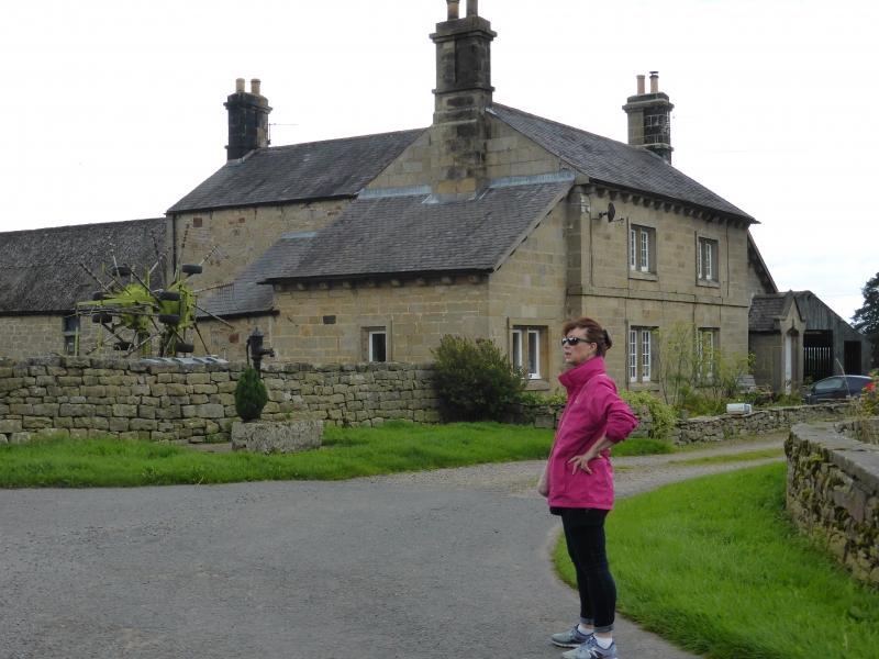
18/93 Matfen Piers Farmhouse
GV II
Farmhouse. c1840. Dressed stone with Welsh slate roof. L-plan. 2 storeys.
2-bay centre with symmetrically-placed single-storey lean-to on each return.
Tudor-arched door in gabled stone porch with kneelers in right lean-to. 2-light
mullioned windows with 12-pane casements in raised and chamfered surrounds.
Similar window in left lean-to has lost its small-paned casements. 1st floor
band.
Eaves and lean-to eaves supported on rounded stone corbels. Gabled roof with
partly-projecting stone corniced and conjoined end stacks.
Windows to rear are 16-pane Yorkshire sashes.
Similar end stack on rear wing.
Listing NGR: NZ0319868600
External links are from the relevant listing authority and, where applicable, Wikidata. Wikidata IDs may be related buildings as well as this specific building. If you want to add or update a link, you will need to do so by editing the Wikidata entry.


Other nearby listed buildings