Approximate Location Map
Large Map »
Latitude: 54.8891 / 54°53'20"N
Longitude: -2.001 / 2°0'3"W
OS Eastings: 400032
OS Northings: 554927
OS Grid: NZ000549
Mapcode National: GBR GCGX.L6
Mapcode Global: WHB2T.7CDS
Plus Code: 9C6VVXQX+JH
Entry Name: Donald's Grave, on South Side of Road 10 Metres East of Track to Slaley Hall
Listing Date: 18 June 1986
Grade: II
Source: Historic England
Source ID: 1045376
English Heritage Legacy ID: 240488
ID on this website: 101045376
Location: Northumberland, DH8
County: Northumberland
Civil Parish: Healey
Traditional County: Northumberland
Lieutenancy Area (Ceremonial County): Northumberland
Church of England Parish: Healey St John
Church of England Diocese: Newcastle
Tagged with: Building
HEALEY
NZ 05 SW NY 0004 5493
16/116 Donald's Grave, on
south side of road
10 metres east of
track to Slaley Hall
II
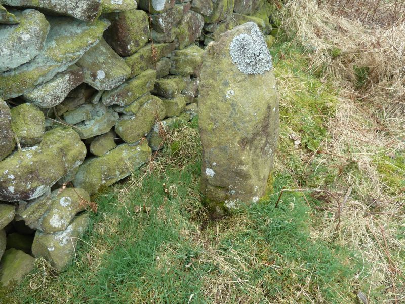
Probable boundary marker, C18 or perhaps a reworking of a more ancient stone.
Gritstone. Roughly-cut monolith of trapezoidal plan, exposed height 0.9 metres.
East face with incised B; north face with remains of incised design, possibly
a cross within a circle; west face incised A (laid sideways) and S.
Listing NGR: NZ0003254927
External links are from the relevant listing authority and, where applicable, Wikidata. Wikidata IDs may be related buildings as well as this specific building. If you want to add or update a link, you will need to do so by editing the Wikidata entry.


Other nearby listed buildings
