Approximate Location Map
Large Map »
Latitude: 53.0381 / 53°2'17"N
Longitude: -0.9956 / 0°59'44"W
OS Eastings: 467441
OS Northings: 349454
OS Grid: SK674494
Mapcode National: GBR 9J4.F42
Mapcode Global: WHFHL.PW2S
Plus Code: 9C5X22Q3+6P
Entry Name: The Old Sheepwash and Footbridge
Listing Date: 11 August 1952
Grade: II
Source: Historic England
Source ID: 1045570
English Heritage Legacy ID: 242054
ID on this website: 101045570
Location: Newark and Sherwood, Nottinghamshire, NG14
County: Nottinghamshire
District: Newark and Sherwood
Civil Parish: Thurgarton
Traditional County: Nottinghamshire
Lieutenancy Area (Ceremonial County): Nottinghamshire
Church of England Parish: Thurgarton
Church of England Diocese: Southwell and Nottingham
Tagged with: Building
SK 64 NE
4/102
11.8.52
THURGARTON
over THURGARTON BECK
The Old Sheepwash and Footbridge
II
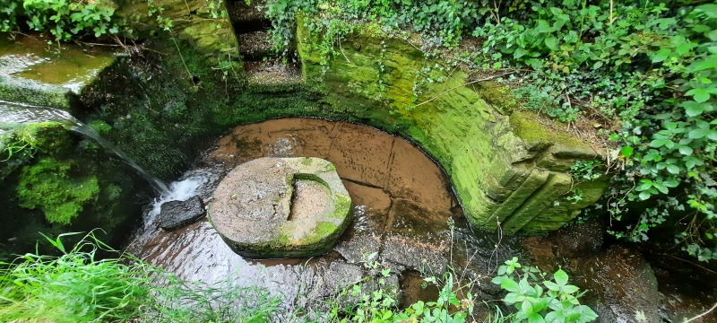
Footbridge and sheepwash. Late C17. Dressed coursed rubble.
Foot bridge with single arch and parapet to each side. The
western arch with groove for shutter. Below the bridge is a
rill, being paved, with a wall extending from the left which
drops down, further extends and curves around. The wall on the
right is lower and is broken by a small flight of stone steps
which run at a sharp angle to the wall. The angle between the
steps and the wall contains a stone trough. At the other side of
the steps the wall continues in a semi-circular curve, there is
then a small straight section with grooves for a shutter and
finally a section where the wall curves around similarly to the
left side. The water drops down steeply just before the flight
of steps. Next to the steps and placed in the centre of the rill
is a large oval stone container.
Listing NGR: SK6744149454
External links are from the relevant listing authority and, where applicable, Wikidata. Wikidata IDs may be related buildings as well as this specific building. If you want to add or update a link, you will need to do so by editing the Wikidata entry.


Other nearby listed buildings
