Latitude: 53.1754 / 53°10'31"N
Longitude: -1.0359 / 1°2'9"W
OS Eastings: 464534
OS Northings: 364690
OS Grid: SK645646
Mapcode National: GBR 9GB.WDG
Mapcode Global: WHFH0.1GZ0
Plus Code: 9C5W5XG7+5J
Entry Name: Water Tower and Boundary Wall at Rufford Abbey
Listing Date: 10 July 1975
Grade: II
Source: Historic England
Source ID: 1045602
English Heritage Legacy ID: 241923
ID on this website: 101045602
Location: Newark and Sherwood, Nottinghamshire, NG22
County: Nottinghamshire
District: Newark and Sherwood
Civil Parish: Rufford
Built-Up Area: Rufford Country Park
Traditional County: Nottinghamshire
Lieutenancy Area (Ceremonial County): Nottinghamshire
Church of England Parish: Wellow
Church of England Diocese: Southwell and Nottingham
Tagged with: Water tower
SK 66 SW
6/71
10.7.75
RUFFORD
off MAY LODGE DRIVE (north side)
Water Tower and boundary wall at Rufford Abbey
G.V.
II
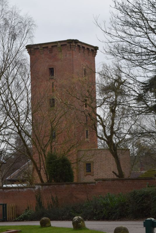
Water tower. Late C19. By John Birch. Brick. Ashlar
dressings. Bracketed ashlar eaves band with foliate corner
brackets. Square plan. 5 stages. Unglazed windows have
projecting ashlar architraves. To north, chamfered doorway.
Each stage, above, has 4 windows. To west, single storey, single
bay building, dressed stone. To north, doorway with segmental
head. Adjoining boundary wall, irregularly coursed dressed stone
and brick, with shaped ashlar coping. Semi-circular plan with 2
gateways. Approx. 60 M long.
Listing NGR: SK6453464690
External links are from the relevant listing authority and, where applicable, Wikidata. Wikidata IDs may be related buildings as well as this specific building. If you want to add or update a link, you will need to do so by editing the Wikidata entry.


Other nearby listed buildings