Latitude: 52.9523 / 52°57'8"N
Longitude: -0.9499 / 0°56'59"W
OS Eastings: 470648
OS Northings: 339947
OS Grid: SK706399
Mapcode National: GBR BLH.ST8
Mapcode Global: WHFJ6.C2X1
Plus Code: 9C4XX322+W2
Entry Name: Number 7 with Adjoining Outbuilding, Boundary Walls and Water Pump
Listing Date: 10 June 1985
Grade: II
Source: Historic England
Source ID: 1045659
English Heritage Legacy ID: 241747
ID on this website: 101045659
Location: Bingham, Rushcliffe, Nottinghamshire, NG13
County: Nottinghamshire
District: Rushcliffe
Civil Parish: Bingham
Built-Up Area: Bingham
Traditional County: Nottinghamshire
Lieutenancy Area (Ceremonial County): Nottinghamshire
Church of England Parish: Bingham
Church of England Diocese: Southwell and Nottingham
Tagged with: Building
BINGHAM CHURCH STREET
SK 7039
(north side)
No.7 with adjoining
12/2 outbuilding, bound-
ary walls and water
10.6.85 pump
6/85
II
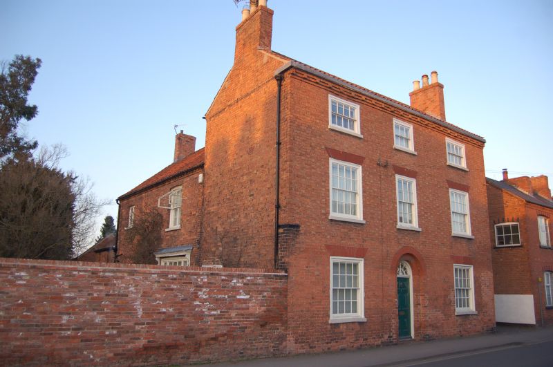
House, with adjoining boundary walls and water pump. Late C18.
Brick and mud. Pantile roofs. Dentillated and cogged eaves. 3
gable and single ridge stacks. 3 storeys, 3 bays. T-plan.
Windows are mainly glazing bar sashes with rubbed brick heads.
South front has central rebated round headed opening with part
glazed door and fanlight. Flanked by single sashes. Above, 3
sashes. Above again, 3 smaller sashes. At rear, 2 storey lean-
to addition in return angle, with C19 fenestration. Rear wing
has to east, C19 door and casement, and above, 2 sashes, all with
segmental heads. Single storey outbuildings, brick with pantile
roofs, 3 unequal bays, have attached lead pump with timber case,
scrolled iron handle and stone trough. To west, brick boundary
wall with corbelled brick coping, 30M long. To north, mud
boundary wall with partial brick plinth and gabled pantile
coping. Whitewashed. Approx. 30M long.
Listing NGR: SK7064839947
External links are from the relevant listing authority and, where applicable, Wikidata. Wikidata IDs may be related buildings as well as this specific building. If you want to add or update a link, you will need to do so by editing the Wikidata entry.


Other nearby listed buildings