Latitude: 53.1478 / 53°8'52"N
Longitude: -0.8465 / 0°50'47"W
OS Eastings: 477242
OS Northings: 361808
OS Grid: SK772618
Mapcode National: GBR BJ9.NSK
Mapcode Global: WHFH8.Z41N
Plus Code: 9C5X45X3+49
Entry Name: Willoughby Farmhouse and Adjoining Boundary Railing
Listing Date: 19 September 1985
Grade: II
Source: Historic England
Source ID: 1045953
English Heritage Legacy ID: 242785
ID on this website: 101045953
Location: Norwell, Newark and Sherwood, Nottinghamshire, NG23
County: Nottinghamshire
District: Newark and Sherwood
Civil Parish: Norwell
Built-Up Area: Norwell
Traditional County: Nottinghamshire
Lieutenancy Area (Ceremonial County): Nottinghamshire
Church of England Parish: Norwell
Church of England Diocese: Southwell and Nottingham
Tagged with: Farmhouse
SK 76 SE NORWELL MAIN STREET
(north side)
4/81 Willoughby Farm
House and
adjoining boundary
railing
II
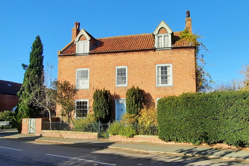
Farmhouse. Early C19. Brick with pantile roof. Cogged eaves,
coped gables with kneelers, 3 gable stacks. 2 storeys plus
attics, 3 bays. L-plan. All openings have segmental heads.
Front has central panelled door with overlight, flanked by single
glazing bar sashes. Above, smaller central glazing bar sash,
flanked by single glazing bar sashes. Above again, 2 C19 gabled
cross-eaves dormers with plain tile roofs and bargeboards, with
C20 casements. C19 2 storey rear wing has plain tile roof.
Adjoining dwarf brick boundary wall with ashlar coping, 2 cast
iron piers, wrought iron railing and matching gate.
Listing NGR: SK7724261808
External links are from the relevant listing authority and, where applicable, Wikidata. Wikidata IDs may be related buildings as well as this specific building. If you want to add or update a link, you will need to do so by editing the Wikidata entry.


Other nearby listed buildings