Latitude: 53.0788 / 53°4'43"N
Longitude: -0.957 / 0°57'25"W
OS Eastings: 469966
OS Northings: 354017
OS Grid: SK699540
Mapcode National: GBR BJX.YPT
Mapcode Global: WHFHF.8WJ3
Plus Code: 9C5X32HV+G6
Entry Name: Boundary Wall and Gate at Hardwick House
Listing Date: 9 February 1973
Last Amended: 20 May 1992
Grade: II
Source: Historic England
Source ID: 1046115
English Heritage Legacy ID: 242448
ID on this website: 101046115
Location: Southwell, Newark and Sherwood, Nottinghamshire, NG25
County: Nottinghamshire
District: Newark and Sherwood
Civil Parish: Southwell
Built-Up Area: Southwell
Traditional County: Nottinghamshire
Lieutenancy Area (Ceremonial County): Nottinghamshire
Church of England Parish: Southwell St Mary the Virgin
Church of England Diocese: Southwell and Nottingham
Tagged with: Wall
SOUTHWELL
QUEEN STREET
SK6954
1919-0/6/142 (South West side)
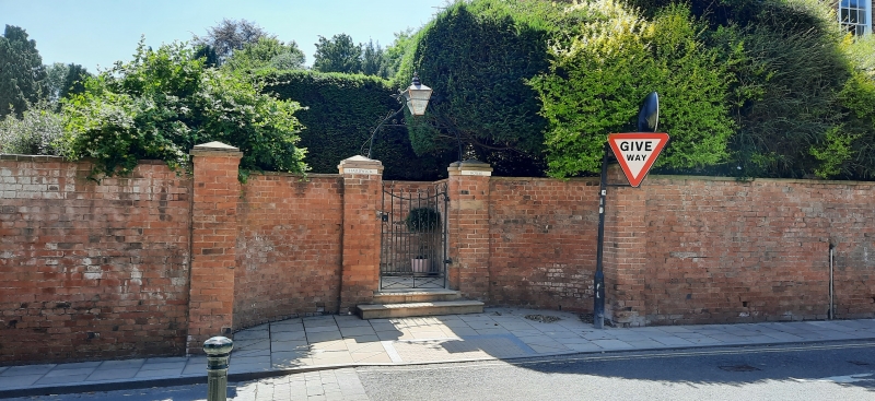
09/02/73 Boundary wall and gate at Hardwick
House
(Formerly Listed as:
QUEEN STREET
with Hardwick House)
GV II
Boundary wall and gate. Early C19. Brick with stone dressings.
Ramped coped boundary wall has an off-centre entrance with a
pair of incurved walls with square piers and pyramidal caps.
Steps to wrought iron gate. Approx. 55M long.
Listing NGR: SK6996654017
External links are from the relevant listing authority and, where applicable, Wikidata. Wikidata IDs may be related buildings as well as this specific building. If you want to add or update a link, you will need to do so by editing the Wikidata entry.


Other nearby listed buildings