Approximate Location Map
Large Map »
Latitude: 53.0763 / 53°4'34"N
Longitude: -0.9499 / 0°56'59"W
OS Eastings: 470447
OS Northings: 353744
OS Grid: SK704537
Mapcode National: GBR BK4.0PM
Mapcode Global: WHFHF.CYX0
Plus Code: 9C5X33G2+G2
Entry Name: Garden Boundary Wall at 41 Church Street
Listing Date: 20 May 1992
Grade: II
Source: Historic England
Source ID: 1046147
English Heritage Legacy ID: 242321
ID on this website: 101046147
Location: Easthorpe, Newark and Sherwood, Nottinghamshire, NG25
County: Nottinghamshire
District: Newark and Sherwood
Civil Parish: Southwell
Built-Up Area: Southwell
Traditional County: Nottinghamshire
Lieutenancy Area (Ceremonial County): Nottinghamshire
Church of England Parish: Southwell St Mary the Virgin
Church of England Diocese: Southwell and Nottingham
Tagged with: Building
SOUTHWELL
CHURCH STREET
SK7053
1919-0/11/31 (North side)
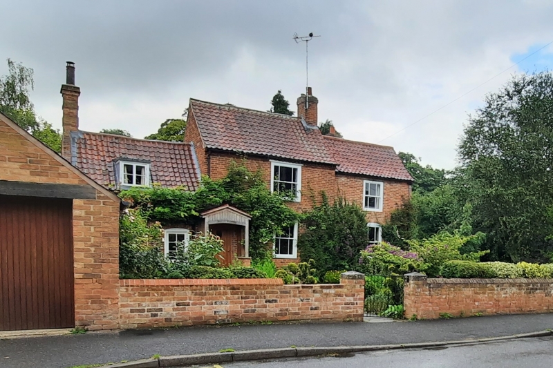
Garden boundary wall at 41 Church
Street
GV II
Garden boundary wall. Early C19. Brick with gabled brick
coping and stone caps to gatepiers. Approx. 45M long, with
off-centre gateway with square piers and wrought iron gate.
Included for group value.
Listing NGR: SK7044753744
External links are from the relevant listing authority and, where applicable, Wikidata. Wikidata IDs may be related buildings as well as this specific building. If you want to add or update a link, you will need to do so by editing the Wikidata entry.


Other nearby listed buildings
