Approximate Location Map
Large Map »
Latitude: 51.8968 / 51°53'48"N
Longitude: -1.1504 / 1°9'1"W
OS Eastings: 458558
OS Northings: 222364
OS Grid: SP585223
Mapcode National: GBR 8XJ.3YV
Mapcode Global: VHCX4.0LP9
Plus Code: 9C3WVRWX+PR
Entry Name: 47, Market Square
Listing Date: 30 March 1970
Grade: II
Source: Historic England
Source ID: 1046458
English Heritage Legacy ID: 243540
ID on this website: 101046458
Location: Bicester, Cherwell, Oxfordshire, OX26
County: Oxfordshire
District: Cherwell
Civil Parish: Bicester
Built-Up Area: Bicester
Traditional County: Oxfordshire
Lieutenancy Area (Ceremonial County): Oxfordshire
Church of England Parish: Bicester with Caversfield
Church of England Diocese: Oxford
Tagged with: Building
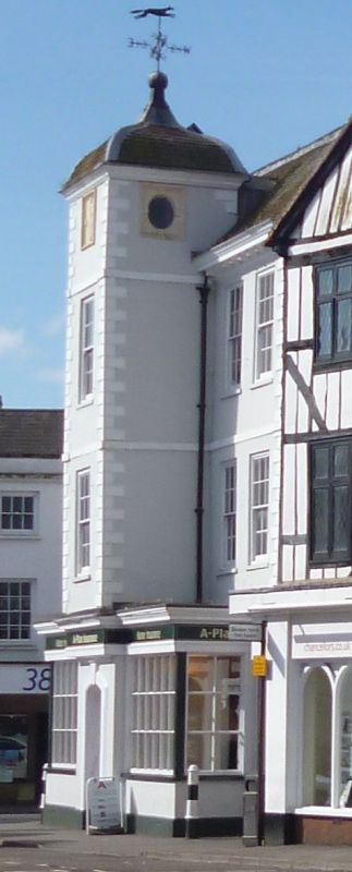
BICESTER MARKET SQUARE
SP5822S
3/65 No.47
30/03/70
GV II
Shown as No.48 on Ordnance Survey map.
Substantial town house, now offices, 1698 on datestone, altered C19 and C20.
Rendered timber framing with stucco dressings; concrete plain-tile and lead
roofs with brick stacks. Double-depth plan. 3 storeys plus attics. Symmetrical
5-window front, with storeybands and rusticated stucco quoins, has 12-pane
sashes to the upper windows, and has a central projecting 4-storey tower with
similar windows at first and second floors, but with 3 keyed oval windows to the
top stage formed in moulded limestone-rectangular frames, the front oval blind
and inscribed "B/IM/1698". The turret has a moulded wooden cornice and an ogee
tiled roof topped by a ball finial and wrought-iron weathervane. The hipped roof
of the main range has a central lead flat and a wooden modillion cornice which
returns on both sides. Ground floor has a central doorway with a moulded
segmental-arched eared stucco architrave, flanked by small-pane shop windows
built out below a deep moulded cornice (probably all C20). Left side has 2
sashes per floor above a C19 ground-floor extension with a large small-pane
window. Right side has some narrower sashes and some altered windows. Rear has 3
truncated stacks, each of 3 linked shafts. Interior: upper floors of tower
retain a dog-leg stair with heavy moulded handrail and closed string,
barleytwist-on-vase balusters, and some turned pendants. With Nos.49 and 50
(q.v.), forms a prominent group on an island site.
(V.C.H.: Oxfordshire, Vol.VI, p.18; Buildings of England: Oxfordshire, p.455).
Listing NGR: SP5855622377
External links are from the relevant listing authority and, where applicable, Wikidata. Wikidata IDs may be related buildings as well as this specific building. If you want to add or update a link, you will need to do so by editing the Wikidata entry.


Other nearby listed buildings
