Approximate Location Map
Large Map »
Latitude: 51.7534 / 51°45'12"N
Longitude: -1.2569 / 1°15'24"W
OS Eastings: 451391
OS Northings: 206340
OS Grid: SP513063
Mapcode National: GBR 8Z4.117
Mapcode Global: VHCXV.56D5
Plus Code: 9C3WQP3V+96
Entry Name: Jesus College, West Range, First Quadrangle
Listing Date: 12 January 1954
Grade: I
Source: Historic England
Source ID: 1046726
English Heritage Legacy ID: 244940
ID on this website: 101046726
Location: Oxford, Oxfordshire, OX1
County: Oxfordshire
District: Oxford
Electoral Ward/Division: Carfax
Parish: Non Civil Parish
Built-Up Area: Oxford
Traditional County: Oxfordshire
Lieutenancy Area (Ceremonial County): Oxfordshire
Church of England Parish: Oxford St Michael and St Martin and All Saints
Church of England Diocese: Oxford
Tagged with: Architectural structure
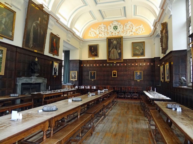
JESUS COLLEGE
1.
1485
First Quadrangle
West Range
SP 5106 SW 8/317O 12.1.54.
I
2.
Contains Kitchen (on South), Buttery and Hall, built circa 1617; the battlements
and top storey are modern. The West side corresponds with the other sides
of the Inner Quad. The hall contains contemporary woodwork and was ceiled
in 1741, the original roof timbers being concealed by attics. The Buttery
and Kitchen were re-modelled after a fire in 1913.
Listing NGR: SP5139606336
External links are from the relevant listing authority and, where applicable, Wikidata. Wikidata IDs may be related buildings as well as this specific building. If you want to add or update a link, you will need to do so by editing the Wikidata entry.


Other nearby listed buildings
