Latitude: 52.0725 / 52°4'21"N
Longitude: -1.3929 / 1°23'34"W
OS Eastings: 441708
OS Northings: 241748
OS Grid: SP417417
Mapcode National: GBR 7SR.2MX
Mapcode Global: VHBYR.T50J
Plus Code: 9C4W3JF4+2R
Entry Name: Wall, Steps and Raised Pavement at Church of All Saints
Listing Date: 20 September 1988
Grade: II
Source: Historic England
Source ID: 1046806
English Heritage Legacy ID: 244742
ID on this website: 101046806
Location: Wroxton, Cherwell, Oxfordshire, OX15
County: Oxfordshire
District: Cherwell
Civil Parish: Wroxton
Built-Up Area: Wroxton
Traditional County: Oxfordshire
Lieutenancy Area (Ceremonial County): Oxfordshire
Church of England Parish: Wroxton with Balscote
Church of England Diocese: Oxford
Tagged with: Wall
SP4040-4140
10/185
WROXTON
CHURCH STREET
(East side)
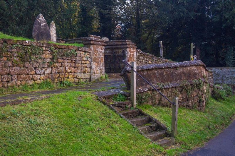
Wall, steps and raised pavement at Church of All Saints
GV
II
Raised pavement, steps and wall. Probably C18. Wall of coursed ironstone rubble
and ashlar. At main gate to the church. Ironstone steps with railing leading
from road to raised pavement of cobblestones. Included for group value.
Listing NGR: SP4170841748
External links are from the relevant listing authority and, where applicable, Wikidata. Wikidata IDs may be related buildings as well as this specific building. If you want to add or update a link, you will need to do so by editing the Wikidata entry.


Other nearby listed buildings