Latitude: 51.5373 / 51°32'14"N
Longitude: -0.9046 / 0°54'16"W
OS Eastings: 476070
OS Northings: 182610
OS Grid: SU760826
Mapcode National: GBR C4S.D49
Mapcode Global: VHDWG.8MMD
Plus Code: 9C3XG3PW+W5
Entry Name: 4, Duke Street
Listing Date: 28 October 1974
Grade: II
Source: Historic England
Source ID: 1047001
English Heritage Legacy ID: 246090
ID on this website: 101047001
Location: Henley-on-Thames, South Oxfordshire, RG9
County: Oxfordshire
District: South Oxfordshire
Civil Parish: Henley-on-Thames
Built-Up Area: Henley-on-Thames
Traditional County: Oxfordshire
Lieutenancy Area (Ceremonial County): Oxfordshire
Church of England Parish: Henley-on-Thames
Church of England Diocese: Oxford
Tagged with: Building
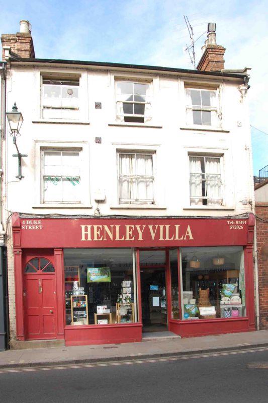
1. DUKE STREET
5355 (West Side)
No 4
SU 7582 1/237
II GV
2.
Early/mid C19 facade. Painted brick with double span roof, stone coped
gable ends and stone kneelers (roofing material not visible). 3 storeys,
3 windows, these of 1st and 2nd floors with moulded stucco architraves.
Unbarred sashes. Ground floor has altered C19 shop front.
Nos 2 to 6 (even) form a group.
Listing NGR: SU7607082610
External links are from the relevant listing authority and, where applicable, Wikidata. Wikidata IDs may be related buildings as well as this specific building. If you want to add or update a link, you will need to do so by editing the Wikidata entry.


Other nearby listed buildings