Approximate Location Map
Large Map »
Latitude: 51.7664 / 51°45'59"N
Longitude: -1.2592 / 1°15'33"W
OS Eastings: 451218
OS Northings: 207789
OS Grid: SP512077
Mapcode National: GBR 8YY.6GB
Mapcode Global: VHCXN.4V5Q
Plus Code: 9C3WQP8R+H8
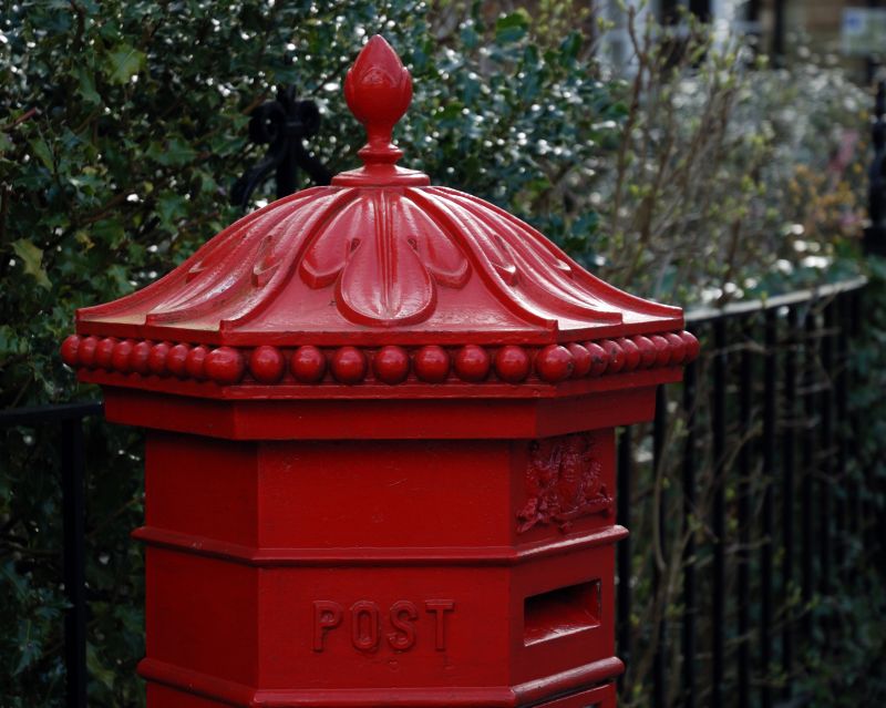
Entry Name: Letterbox at West End of the Crescent Garden
Listing Date: 28 June 1972
Grade: II
Source: Historic England
Source ID: 1047180
English Heritage Legacy ID: 245732
ID on this website: 101047180
Location: Park Town, Oxford, Oxfordshire, OX2
County: Oxfordshire
District: Oxford
Electoral Ward/Division: North
Parish: Non Civil Parish
Built-Up Area: Oxford
Traditional County: Oxfordshire
Lieutenancy Area (Ceremonial County): Oxfordshire
Church of England Parish: Oxford St Andrew
Church of England Diocese: Oxford
PARKTOWN
1.
1485
Letterbox at West end
of The Crescent garden
SP 5107 NW 1/801
II GV
2.
1865. 'Hexagonal Penfold' type.
All the listed buildings in Parktown form a group, with Nos 68 and 70 Banbury
Road
Listing NGR: SP5121807789
External links are from the relevant listing authority and, where applicable, Wikidata. Wikidata IDs may be related buildings as well as this specific building. If you want to add or update a link, you will need to do so by editing the Wikidata entry.


Other nearby listed buildings
