Approximate Location Map
Large Map »
Latitude: 51.6384 / 51°38'18"N
Longitude: -1.1351 / 1°8'6"W
OS Eastings: 459947
OS Northings: 193647
OS Grid: SU599936
Mapcode National: GBR 90N.7TF
Mapcode Global: VHCYH.82RS
Plus Code: 9C3WJVQ7+9W
Entry Name: Nelly's Bar
Listing Date: 14 May 1986
Last Amended: 15 May 1986
Grade: II
Source: Historic England
Source ID: 1048086
English Heritage Legacy ID: 248212
Also known as: Mike
ID on this website: 101048086
Location: Warborough, South Oxfordshire, OX10
County: Oxfordshire
District: South Oxfordshire
Civil Parish: Warborough
Built-Up Area: Warborough
Traditional County: Oxfordshire
Lieutenancy Area (Ceremonial County): Oxfordshire
Church of England Parish: Warborough
Church of England Diocese: Oxford
Tagged with: Building
WARBOROUGH THE GREEN NORTH
SU5993 (South side)
9/181 Nelly's Bar
GV II
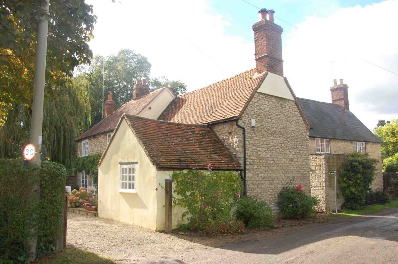
Public house. Probably C17, refronted early/mid C18 and extended late C18.
Clunch rubble with some brick dressings; old plain-tile roof with brick stacks.
L-plan. 2 storeys. 4-window front has taller 2-window section, breaking forward
to left, with brick quoins, dentil eaves course and segmental arches to ground
floor windows; upper windows retain horizontal-sliding sashes. Central entrance
now within C20 porch. Right gable wall is probably timber framed and abuts lower
rubble range with 2 small first-floor casements above a C20 front extension.
Roof has stacks to left and right, plus a ridge stack in line with entrance.
Hipped end to left, returns to a long later rear range; bordering the
churchyard, with some Flemish-bond brickwork at the far end. Rear of main range
is of rendered timber framing with a small horizontal-sliding sash and a further
blocked entrance in line with stack. Interior not inspected but likely to be a
lobby-entry plan.
Listing NGR: SU5994793647
External links are from the relevant listing authority and, where applicable, Wikidata. Wikidata IDs may be related buildings as well as this specific building. If you want to add or update a link, you will need to do so by editing the Wikidata entry.


Other nearby listed buildings
