Latitude: 52.633 / 52°37'58"N
Longitude: 1.3003 / 1°18'1"E
OS Eastings: 623431
OS Northings: 309027
OS Grid: TG234090
Mapcode National: GBR WB2.1C
Mapcode Global: WHMTM.Y2CT
Plus Code: 9F43J8M2+54
Entry Name: Precinct Wall
Listing Date: 5 June 1972
Last Amended: 8 April 1986
Grade: II*
Source: Historic England
Source ID: 1051331
English Heritage Legacy ID: 228919
ID on this website: 101051331
Location: The Close, Norwich, Norfolk, NR3
County: Norfolk
District: Norwich
Electoral Ward/Division: Thorpe Hamlet
Parish: Non Civil Parish
Built-Up Area: Norwich
Traditional County: Norfolk
Lieutenancy Area (Ceremonial County): Norfolk
Church of England Parish: Norwich St George, Tombland
Church of England Diocese: Norwich
Tagged with: Wall
TG 2308 NW, TG 2309 SE, TG 2309 SW, THE CLOSE
TG 2308 NE
11/302 12/302 16/302, 17/302
5.6.72 Precinct Wall (Formerly listed
under Bishopgate).
GV II*
See also Bishopgate, Palace Street, St. Faith's Lane.
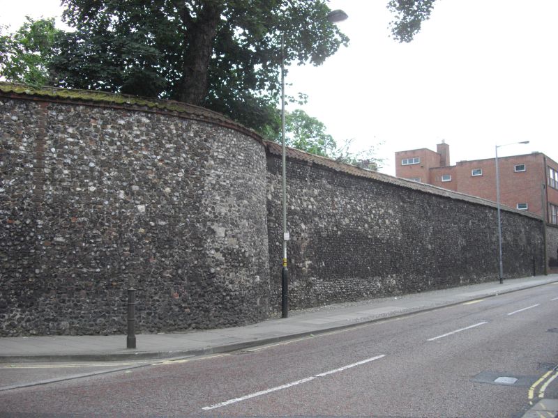
Precinct Wall to Cathedral Close. C13 and Later with much C18 and C19
re-building. Brick, flint and rubble with tiled coping.
The sections remaining are:- between Erpingham and St. Ethelbert's Gates
behind buildings in Tombland and the Close, and extending a little to
north and south. South-west corner only below the level of the lane as
far as the end of No. 4 The Close. Over 6ft high from behind Nos. 5
and 6 to the end of the garden. From the wall of No.6 garden following
St. Faith's Lane, a C18 rebuilding (possibly on earlier foundations)
to the Horsefair. C13 flint wall extends south from Horsefair to far
end of No. 24. The earlier wall survives in part along Nos. 22, 23
and 24, next to Ferry Lane. C13 and later east wall of Close from Ferry Gate
to south boundary. C12 close boundary wall facing south boundary of gardens,
from Nos. 44-59 The Close. 7 arches from the former wall walk remain in the
north-east corner of Bishop's Palace Garden. Arches have been removed from
the adjoining east section.
Listing NGR: TG2343109027
External links are from the relevant listing authority and, where applicable, Wikidata. Wikidata IDs may be related buildings as well as this specific building. If you want to add or update a link, you will need to do so by editing the Wikidata entry.


Other nearby listed buildings