Latitude: 52.6305 / 52°37'49"N
Longitude: 1.3041 / 1°18'14"E
OS Eastings: 623700
OS Northings: 308762
OS Grid: TG237087
Mapcode National: GBR WBN.QY
Mapcode Global: WHMTN.049R
Plus Code: 9F43J8J3+5M
Entry Name: 20, the Close
Listing Date: 5 June 1972
Grade: II
Source: Historic England
Source ID: 1051338
English Heritage Legacy ID: 228937
ID on this website: 101051338
Location: Thorpe Hamlet, Norwich, Norfolk, NR1
County: Norfolk
District: Norwich
Electoral Ward/Division: Thorpe Hamlet
Parish: Non Civil Parish
Built-Up Area: Norwich
Traditional County: Norfolk
Lieutenancy Area (Ceremonial County): Norfolk
Tagged with: Building
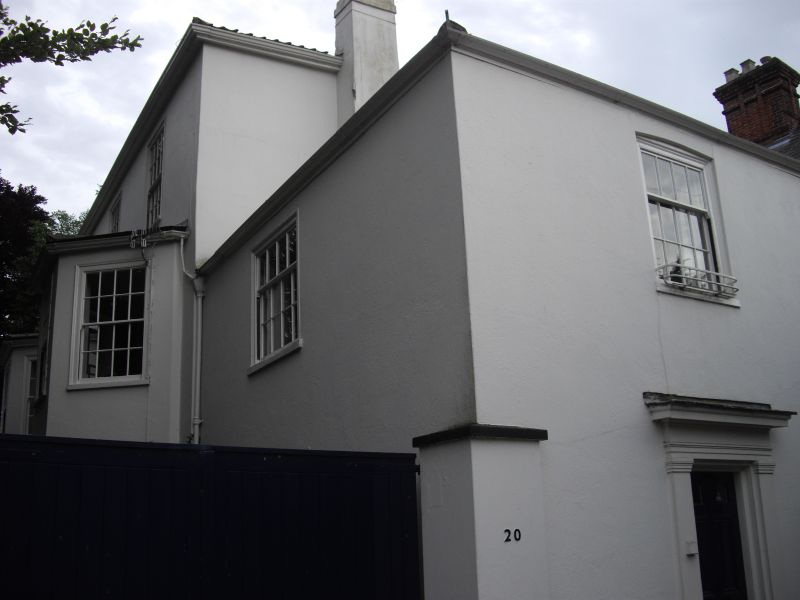
TG 2308 NE THE CLOSE
17/188
5.6.72 No.20
GV II
House. Early C19. Rendered brick. Pantile roof at right angles to
street liner 3 storeys. 3 bays. Central door. 2-storey bay windows in
end-bays. Sash windows throughout with glazing bars and moulded surround.
Moulded eaves cornices 2 storey right-hand extension:- street facade with
simple doorcase having pilasters and one sash window above.
Listing NGR: TG2370008761
External links are from the relevant listing authority and, where applicable, Wikidata. Wikidata IDs may be related buildings as well as this specific building. If you want to add or update a link, you will need to do so by editing the Wikidata entry.


Other nearby listed buildings