Approximate Location Map
Large Map »
Latitude: 52.5939 / 52°35'38"N
Longitude: 1.5549 / 1°33'17"E
OS Eastings: 640867
OS Northings: 305507
OS Grid: TG408055
Mapcode National: GBR XKT.9YG
Mapcode Global: WHMTY.V2M7
Plus Code: 9F43HHV3+HX
Entry Name: Church of All Saints
Listing Date: 25 September 1962
Grade: II*
Source: Historic England
Source ID: 1051456
English Heritage Legacy ID: 228619
ID on this website: 101051456
Location: All Saints' Church, Freethorpe, Broadland, Norfolk, NR13
County: Norfolk
District: Broadland
Civil Parish: Freethorpe
Built-Up Area: Freethorpe
Traditional County: Norfolk
Lieutenancy Area (Ceremonial County): Norfolk
Church of England Parish: Freethorpe
Church of England Diocese: Norwich
Tagged with: Church building
FREETHORPE THE GREEN (west)
TG 40 NW
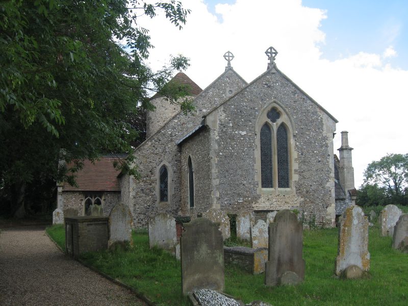
4/42 Church of All Saints.
25.9.62
G.V. II*
Parish church, medieval and later, restored 1850 for Henry Vade. Built of
flint with stone dressings with plain tile and lead roofs. West tower, south
porch, north aisle, south aisle, nave, north chancel chapel and chancel. Round
tower, probably Norman, partially of coursed flint. Single light west window,
single light belfry openings, west and south, conical roof. 2 bay north aisle
with off set buttresses. 3 bay south aisle. Mainly C19 south porch. C13 south
doorway with moulded base and roll mouldings. Gabled north chancel chapel,
c.1850. Single light window in north gable wall. Chimney on north east corner.
Single bay chancel. Single light window to south with hood mould and sculpted
label stops. 2-light plate traceried east window. All windows C19. Parapet
gables. Interior mainly C19. Perpendicular tower arch. 2 bay C19 north and
south arcades. Octagonal font bowl on moulded base.
Listing NGR: TG4086705507
External links are from the relevant listing authority and, where applicable, Wikidata. Wikidata IDs may be related buildings as well as this specific building. If you want to add or update a link, you will need to do so by editing the Wikidata entry.


Other nearby listed buildings
