Approximate Location Map
Large Map »
Latitude: 51.9408 / 51°56'26"N
Longitude: -1.5453 / 1°32'43"W
OS Eastings: 431352
OS Northings: 227022
OS Grid: SP313270
Mapcode National: GBR 6SS.64W
Mapcode Global: VHBZ8.5HD0
Plus Code: 9C3WWFR3+8V
Entry Name: 1, High Street
Listing Date: 3 March 1969
Grade: II
Source: Historic England
Source ID: 1052655
English Heritage Legacy ID: 251623
ID on this website: 101052655
Location: Chipping Norton, West Oxfordshire, OX7
County: Oxfordshire
District: West Oxfordshire
Civil Parish: Chipping Norton
Built-Up Area: Chipping Norton
Traditional County: Oxfordshire
Lieutenancy Area (Ceremonial County): Oxfordshire
Church of England Parish: Chipping Norton with Over Norton
Church of England Diocese: Oxford
Tagged with: Building
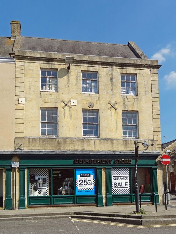
CHIPPING NORTON HIGH STREET
SP 3027-3127
3/12 No 1 (Co-op)
3.3.69
GV
II
Shop. Late C18 of ashlar with rock faced coursed rubble stone to S end wall,
stucco to rear and a gabled slate roof with dressed stone copings and one N brick
stack. Three storeys, 3 bays with banded quoins and moulded stone cornice with
plain course above. Recessed sash windows, top floor 6-pane with 3-pane upper
light, first floor 12 panes. C20 shop front to ground floor.
Listing NGR: SP3135227022
External links are from the relevant listing authority and, where applicable, Wikidata. Wikidata IDs may be related buildings as well as this specific building. If you want to add or update a link, you will need to do so by editing the Wikidata entry.


Other nearby listed buildings
