Approximate Location Map
Large Map »
Latitude: 51.6494 / 51°38'57"N
Longitude: -1.308 / 1°18'28"W
OS Eastings: 447974
OS Northings: 194734
OS Grid: SU479947
Mapcode National: GBR 7YX.D58
Mapcode Global: VHCY6.8SWZ
Plus Code: 9C3WJMXR+PR
Entry Name: Sutton Wick House and Attached Front Forecourt Walls and Gateway
Listing Date: 9 February 1966
Last Amended: 19 February 1988
Grade: II
Source: Historic England
Source ID: 1052744
English Heritage Legacy ID: 251339
ID on this website: 101052744
Location: Drayton, Vale of White Horse, Oxfordshire, OX14
County: Oxfordshire
District: Vale of White Horse
Civil Parish: Drayton
Built-Up Area: Drayton
Traditional County: Berkshire
Lieutenancy Area (Ceremonial County): Oxfordshire
Church of England Parish: Drayton
Church of England Diocese: Oxford
Tagged with: Building
DRAYTON SUTTON WICK LANE
SU4794 (West side)
Sutton Wick
5/36 Sutton Wick House and attached
09/02/66 front forecourt walls and
gateway
(Formerly listed as Sutton
Wick House)
GV II
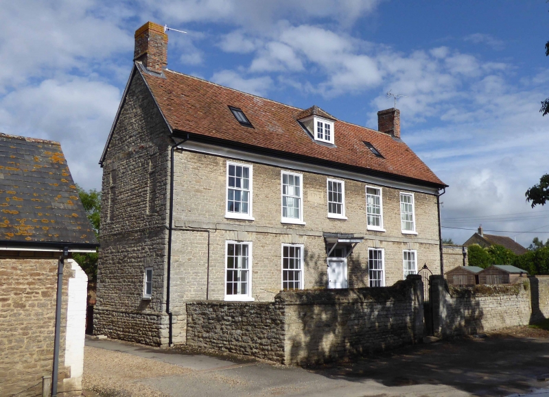
House. Dated 1712 to datestone at first floor left of centre. Coursed squared
stone plinth; coursed squared stone; old plain-tile roof; brick end stacks. 2
storeys and attic 5-window range. 4-panel door to centre with overlight and
flat hood on brackets. 12-pane unhorned sashes to all openings, except 9-pane
unhorned sash to first floor centre; those to ground floor have flat stone
arches with keystones. Flat stone band between ground and first floors, Coved
eaves, Hipped full dormer to centre with 2-light casement. Sloping roof-lights
to left and right of centre. Interior not inspected. Attached stone walls to
front form forecourt with wrought-iron gateway opposing the front door.
Listing NGR: SU4797494734
External links are from the relevant listing authority and, where applicable, Wikidata. Wikidata IDs may be related buildings as well as this specific building. If you want to add or update a link, you will need to do so by editing the Wikidata entry.


Other nearby listed buildings
