Approximate Location Map
Large Map »
Latitude: 51.6901 / 51°41'24"N
Longitude: -1.6405 / 1°38'25"W
OS Eastings: 424945
OS Northings: 199096
OS Grid: SU249990
Mapcode National: GBR 5V7.S3T
Mapcode Global: VHC0C.JS28
Plus Code: 9C3WM9R5+2Q
Entry Name: Lower House
Listing Date: 30 March 1989
Grade: II
Source: Historic England
Source ID: 1053374
English Heritage Legacy ID: 253824
ID on this website: 101053374
Location: Kelmscott, West Oxfordshire, GL7
County: Oxfordshire
District: West Oxfordshire
Civil Parish: Kelmscott
Traditional County: Oxfordshire
Lieutenancy Area (Ceremonial County): Oxfordshire
Church of England Parish: Broadwell with Kelmscott
Church of England Diocese: Oxford
Tagged with: House
KELMSCOTT
SU2499-2599
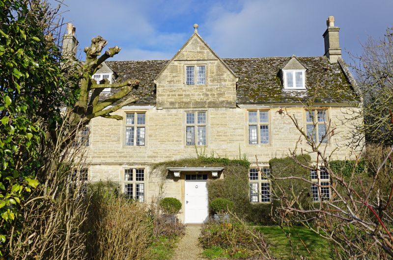
10/72 Lower House
GV II
Farmhouse, now house. Late C17 with minor later additions and alterations.
Roughly coursed limestone rubble; stone slate roof with moulded coped verges and
kneelers. L-plan with low range to rear on right. 2 storeys and attic with
moulded wooden eaves cornice interrupted by central gabled full dormer with
stop-chamfered stone dripmould at eaves level and dripmould above 2-light
mullion window. Moulded coped verges with kneelers and ball finial to apex.
5-window front; chamfered leaded cross windows with continuous dripmould to
ground floor. Gabled 2-light leaded dormers in middle of roof slope to left and
right. Central entrance; 6-panel door in moulded stone surround with rectangular
overlight under flat wooden hood with elaborately carved scrolled brackets.
Integral end stacks with moulded capping and bases. Lean-to attached to rear of
rear range. Interior. Not inspected at time of resurvey (May 1987) but likely to
be of interest.
(Buildings of England: Oxfordshire, p667)
[2367]
Listing NGR: SU2494599096
External links are from the relevant listing authority and, where applicable, Wikidata. Wikidata IDs may be related buildings as well as this specific building. If you want to add or update a link, you will need to do so by editing the Wikidata entry.


Other nearby listed buildings
