Latitude: 52.8109 / 52°48'39"N
Longitude: -2.44 / 2°26'23"W
OS Eastings: 370440
OS Northings: 323795
OS Grid: SJ704237
Mapcode National: GBR 7X.VV4Z
Mapcode Global: WH9CJ.HLBZ
Plus Code: 9C4VRH66+92
Entry Name: Stanford Bridge
Listing Date: 8 April 1983
Grade: II
Source: Historic England
Source ID: 1054121
English Heritage Legacy ID: 361911
ID on this website: 101054121
Location: Standford Bridge, Telford and Wrekin, Shropshire, TF10
County: Telford and Wrekin
Civil Parish: Chetwynd
Traditional County: Shropshire
Lieutenancy Area (Ceremonial County): Shropshire
Church of England Parish: Sambrook St Luke
Church of England Diocese: Lichfield
Tagged with: Bridge
SJ 72 SW; 20/55
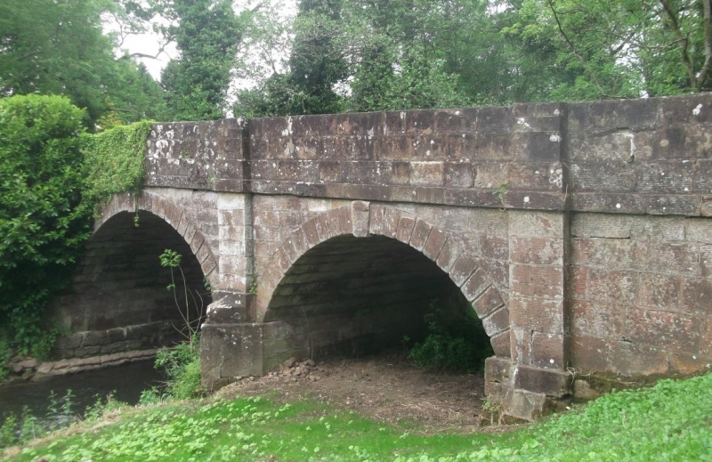
CHETWYND; STANFORD BRIDGE
Stanford Bridge
II
Circa early/mid C19 pink sandstone ashlar road bridge over River Meese. Three
rusticated round arches with keyblocks. Cutwaters with pilasters above. String
course and parapet splayed at ends. Most of the parapet coping is missing.
Listing NGR: SJ7044023795
External links are from the relevant listing authority and, where applicable, Wikidata. Wikidata IDs may be related buildings as well as this specific building. If you want to add or update a link, you will need to do so by editing the Wikidata entry.


Other nearby listed buildings