Approximate Location Map
Large Map »
Latitude: 52.7738 / 52°46'25"N
Longitude: -2.4115 / 2°24'41"W
OS Eastings: 372334
OS Northings: 319660
OS Grid: SJ723196
Mapcode National: GBR 7Y.Y8RP
Mapcode Global: WH9CQ.XJTW
Plus Code: 9C4VQHFQ+G9
Entry Name: Egremont House
Listing Date: 8 April 1983
Grade: II
Source: Historic England
Source ID: 1054182
English Heritage Legacy ID: 362052
ID on this website: 101054182
Location: Edgmond, Telford and Wrekin, Shropshire, TF10
County: Telford and Wrekin
Civil Parish: Edgmond
Built-Up Area: Edgmond
Traditional County: Shropshire
Lieutenancy Area (Ceremonial County): Shropshire
Church of England Parish: Edgmond St Peter
Church of England Diocese: Lichfield
Tagged with: House
EDGMOND HIGH STREET
1.
5362 (north-west side)
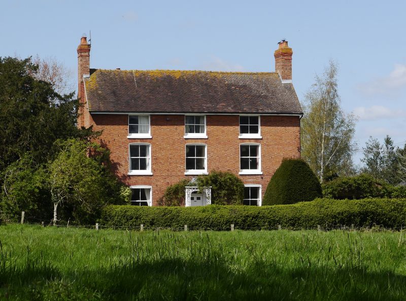
Egremont House
SJ 71 NW 24/187
II
2.
Early C19 red brick house. Plain tile roof with gabled ends. Three storeys. Three
windows. Sashes without glazing bars, in segmental brick arched openings. Central
panelled door with rectangular fanlight and ornate openwork cast-iron porch with
tent-shaped roof. Brick end stacks.
Listing NGR: SJ7233419660
External links are from the relevant listing authority and, where applicable, Wikidata. Wikidata IDs may be related buildings as well as this specific building. If you want to add or update a link, you will need to do so by editing the Wikidata entry.


Other nearby listed buildings
