Approximate Location Map
Large Map »
Latitude: 52.8605 / 52°51'37"N
Longitude: -3.0539 / 3°3'14"W
OS Eastings: 329140
OS Northings: 329749
OS Grid: SJ291297
Mapcode National: GBR 73.RW47
Mapcode Global: WH89X.2C1C
Plus Code: 9C4RVW6W+6C
Entry Name: 11, ALBION HILL (See details for further address information)
Listing Date: 15 May 1986
Grade: II
Source: Historic England
Source ID: 1054349
English Heritage Legacy ID: 255466
ID on this website: 101054349
Location: Croesoswallt, Shropshire, SY11
County: Shropshire
Civil Parish: Oswestry
Built-Up Area: Croesowallt
Traditional County: Shropshire
Lieutenancy Area (Ceremonial County): Shropshire
Church of England Parish: Oswestry St Oswald King and Martyr
Church of England Diocese: Lichfield
Tagged with: Building
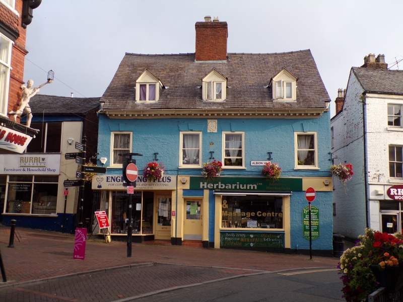
SJ 2929 NW OSWESTRY C.P. ALBION HILL (north side)
14/5 Nos. 11 and 13
-
GV II
House, now divided into shops. C17, re-modelled 1746 (datestone) with
later additions and alterations. Painted and rendered brick facade
with timber frame to rear, slate roof has prominent axial ridge stack to
centre. 2 storeys and attic; wooden modillion eaves cornice; 4-window
front, 3 plate-glass sashes in C18 openings with plain lintels and
projecting keystones to right and wide late C20 casement to left, 3 gabled
dormers in roof slope; late C19 shop front to left and C20 shop front
to right. Cartouche with inscription "P/RE/1746" between central windows
and Salop Fire Insurance Plate below. Lower gabled range to rear has
timber frame (small square panels) exposed to left wall.
Listing NGR: SJ2914229753
External links are from the relevant listing authority and, where applicable, Wikidata. Wikidata IDs may be related buildings as well as this specific building. If you want to add or update a link, you will need to do so by editing the Wikidata entry.


Other nearby listed buildings
