Approximate Location Map
Large Map »
Latitude: 50.9406 / 50°56'26"N
Longitude: -2.6302 / 2°37'48"W
OS Eastings: 355818
OS Northings: 115870
OS Grid: ST558158
Mapcode National: GBR MP.P1GJ
Mapcode Global: FRA 56CM.C5D
Plus Code: 9C2VW9R9+6W
Entry Name: Woborne's Almhouses with Its Boundary Walling 5 Metres to East and South
Listing Date: 17 October 1983
Grade: II
Source: Historic England
Source ID: 1055711
English Heritage Legacy ID: 261337
ID on this website: 101055711
Location: Yeovil, Somerset, BA20
County: Somerset
District: South Somerset
Civil Parish: Yeovil
Built-Up Area: Yeovil
Traditional County: Somerset
Lieutenancy Area (Ceremonial County): Somerset
Tagged with: Building
ST5515NE
8/1
YEOVIL CP
BOND STREET (North side)
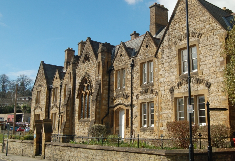
Woborne's Almhouses, with its boundary walling 5 metres to East and South
-
- II
Almhouses. Late C19 rebuilding. Local cut and squared stone with Ham stone
dressings, with Welsh slated roof and tall stone chimney stocks. A 2-storied
building with gables to each of the 7-bays, bays, 1, 4 and 7 being wider and
projecting. Centre bay of one storey, representing the hall or chapel, flunked
by both clasping and angled buttresses, the former terminating in an Octogon
quasi - battlemented; there is a C14 style 3-light traceried window with trefoil
window over: the outer bays have flair chamfer mullioned windows without labels
but with relieving arches over, with plain sash window with one horizontal
glazing bar to each casement, 3-lights to ground floor and 2-lights to first
floor. The remaining bays here 2-light windows to both levels, the upper windows
having no relieving arches: doorways to bays 3 and 5 (the later row with a
window) with segmental arch door and label ith horizontal return over sidelight.
Simple matching side elevations to both Peter Street and South Street. The
interior not inspected. Also included the boundary walling, averaging 1.2 metres
high, local stone with bold copings, gate piers with double pitched finials, and
the simple iron railings with cross finials, as being integral to the setting.
The almhouse was founded in 1416 by John Stone, Rector of Tintinhull, and
re-founded by John Woborne, Canon of St Paul's Cathedral, London, 1476.
Listing NGR: ST5581815870
External links are from the relevant listing authority and, where applicable, Wikidata. Wikidata IDs may be related buildings as well as this specific building. If you want to add or update a link, you will need to do so by editing the Wikidata entry.


Other nearby listed buildings
