Approximate Location Map
Large Map »
Latitude: 51.0535 / 51°3'12"N
Longitude: -2.7339 / 2°44'2"W
OS Eastings: 348654
OS Northings: 128494
OS Grid: ST486284
Mapcode National: GBR MJ.FZ23
Mapcode Global: FRA 565B.DQM
Plus Code: 9C3V3738+9C
Entry Name: Hillhaven and Former Chapel Attached, and Front Boundary Wall
Listing Date: 17 April 1959
Last Amended: 30 September 1985
Grade: II
Source: Historic England
Source ID: 1056679
English Heritage Legacy ID: 263033
ID on this website: 101056679
Location: Somerton, Somerset, TA11
County: Somerset
District: South Somerset
Civil Parish: Somerton
Built-Up Area: Somerton
Traditional County: Somerset
Lieutenancy Area (Ceremonial County): Somerset
Tagged with: Building
ST4828 SOMERTON CP SUTTON ROAD (South side)
8/225 Hillhaven and former chapel
attached
(formerly listed as Zion Chapel
and Chapel House), and front
boundary wall
17.4.59
GV II
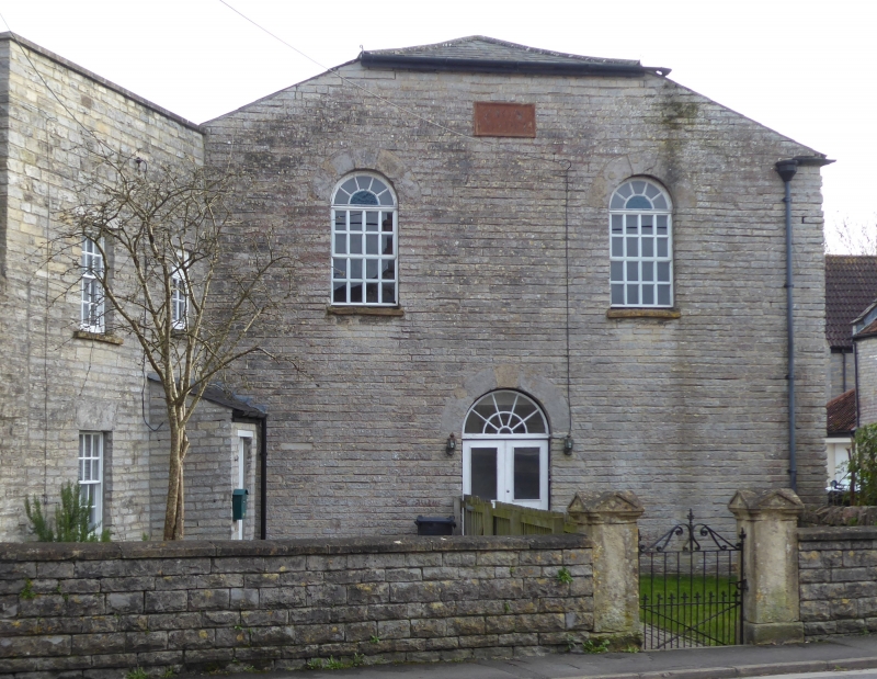
House and former chapel. Early C19. Local lias stone cut and squared; hipped Welsh slate roof to chapel, house roof
hidden behind plain parapet; brick chimney stacks to rear. House 2 storeys, Chapel single storey; both bays. west
elevation of house has 16-pane sash windows with dovetailed stone lintols to bay 1, and to bay 2 a C20 door and porch
with a later small pane casement window; the north elevation of the chapel, abutting this, has two 16-pane sashes with
semi circular radial glazed toplights set rather high, and below and between them a pair of part glazed boarded doors
under marching semi circular fanlight: chapel west elevation has 2 matching but larger windows, the lower sections
altered. Interiors not seen. Extending from corner of former Bible Christian Schoolroom (qv) across forecourt to these
two buildings, enhancing the group value, a 1 metre high wall with shaped coping, square ashlar gate piers with plinths
and 4 gabled tops; wrot and cast iron gate.
Listing NGR: ST4865428494
External links are from the relevant listing authority and, where applicable, Wikidata. Wikidata IDs may be related buildings as well as this specific building. If you want to add or update a link, you will need to do so by editing the Wikidata entry.


Other nearby listed buildings
