Approximate Location Map
Large Map »
Latitude: 51.0552 / 51°3'18"N
Longitude: -2.7277 / 2°43'39"W
OS Eastings: 349095
OS Northings: 128681
OS Grid: ST490286
Mapcode National: GBR MK.FSW9
Mapcode Global: FRA 565B.95F
Plus Code: 9C3V374C+3W
Entry Name: Donisthorpe
Listing Date: 17 April 1959
Grade: II*
Source: Historic England
Source ID: 1056687
English Heritage Legacy ID: 262952
ID on this website: 101056687
Location: Somerton, Somerset, TA11
County: Somerset
District: South Somerset
Civil Parish: Somerton
Built-Up Area: Somerton
Traditional County: Somerset
Lieutenancy Area (Ceremonial County): Somerset
Tagged with: Building
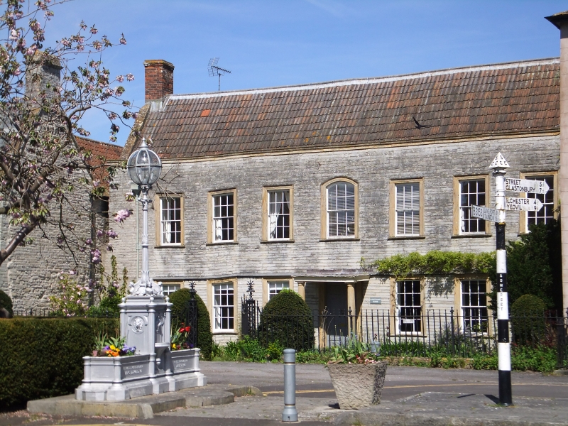
ST49NW SOMERTON CP COW SQUARE (North side)
9/146 Donisthorpe
17.4.59
GV II*
House, formerly detached. Apparently 1770. Local stone cut and squared, with Ham stone dressings; double Roman clay
tile roof behind parapet between coped gables; brick end chimney stacks. Two storeys, 7 bays. Sash windows of 12 panes
in architraved surrounds, that to centre upper bay having segmental arched head; continuous label over ground floor
windows and central open stone portico, which has Doric columns on short plinths carrying moulded flat stone hood;
simple lead rainwater downpipes and stackheads to each side, and simple moulding to plain parapet. VCH states "said to
have been built in 1770" - this could well be a re-modelling. Interior not seen. (VCH, Volume III, 1974).
Listing NGR: ST4909528681
External links are from the relevant listing authority and, where applicable, Wikidata. Wikidata IDs may be related buildings as well as this specific building. If you want to add or update a link, you will need to do so by editing the Wikidata entry.


Other nearby listed buildings
