Latitude: 50.9492 / 50°56'57"N
Longitude: -2.7189 / 2°43'8"W
OS Eastings: 349594
OS Northings: 116890
OS Grid: ST495168
Mapcode National: GBR MK.NGZ7
Mapcode Global: FRA 566L.LL5
Plus Code: 9C2VW7XJ+MC
Entry Name: Abbey Farmhouse and Farm Gate and Stile to North West Corner
Listing Date: 19 April 1961
Last Amended: 27 October 1987
Grade: I
Source: Historic England
Source ID: 1057256
English Heritage Legacy ID: 263546
Also known as: Abbey Farmhouse, Montacute
ID on this website: 101057256
Location: Montacute, Somerset, TA15
County: Somerset
District: South Somerset
Civil Parish: Montacute
Built-Up Area: Montacute
Traditional County: Somerset
Lieutenancy Area (Ceremonial County): Somerset
Tagged with: Farmhouse
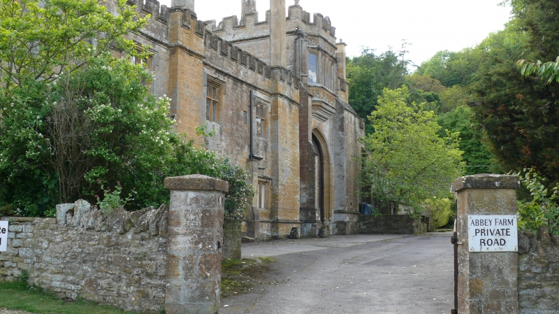
ST4916 MONTACUTE CP ABBEY FARM LANE (South end) 8/91 Abbey Farmhouse (previously listed as Priory Gatehouse), and farm gate and stile to north-west corner 19.4.61 GV I Detached house, incorporating the gateway of the medieval priory. C16, C17 and C19. Ham stone ashlar; stone slate roofs behind castellated parapets with coped gables; stone slab chimney stacks. South elevation 2 storeys, 7 bays, with a 2-storey 2-bay C19 addition to west. Plinth, eaves course, parapets, angled corner and bay buttresses; bay 1 has 3-light hollow-chamfered mullioned windows, no labels; bays 2/4 represent the gateway, bay 2 being an octagonal stair turret with entrance door and three 2-light mullioned 4- centre arched light flat headed window under labels to south-east face, the turret being taller than surrounding work; bay 4 is similar but lower, with 2 matching windows and doorway in south face; between then the tall 4-centre arched gateway with 3 jamb shafts, and above a 1+4+1 light oriel window with 4-centre arched lights, moulded corbel, battlements being angled to the bay, with a device on the central merlon featuring a bishop's mitre and a block sundial over; above and below the oriel are bands of quatrefoil panelling: bays 5, 6 and 7 have hollow chamfered mullioned and transomed windows, 3-light below and 2-light above, all with labels; bay 6 is wider, with a moulded 4-centre arched doorway to the left having incised spandrils and square-stopped label; the merlons to bays 5, 6 and 7 have a variety of carved panels. The extension to the west is set lower, with double Roman clay tiled roof, and 2-light mullioned windows. The east elevation is plain - the chimneys have been removed from a projecting stack here. The north elevation is plainer, with plinth, end buttresses only, eaves course, battlemented parapets: bays 1, 2 and 3 have 2-light mullioned and transomed windows above; to lower bay 2, off-centre, a 2-light chamfer-mullioned window, and to lower bay 3 an ovolo-mould mullioned window, these both with labels; between bays 1/2 and right of bay 3 projections for chimney stacks, the former with offsets, the chimneys probably C20: the main gateway matches the south side except for the absence of stair turrets, with a full-height buttress to the left and a lean-to projection to the right, possibly for another stair, with stepped stone roof and 2 small windows: upper bay 7 has a 2-light mullioned window without label. The western extension has a mullioned window to upper bay 1 and steel windows to bay 2, with a lean-to single-storey building across the front, with a C19 Gothic style door; projection with stepped gable at west end, against which is a farm gateway with single stone gateposts and a step-over stile to north. The interior not seen. The gateway bears the initials T.C., for Thomas Chard, prior 1514-32, and was thus one of the last buildings of this Cluniac house before the Dissolution. In 1539 the property was leased as a farmhouse, being part of the landholding of the Phelips family of Montacute House: it was 'almost desolate' by 1633; some years later it became a residence, but by 1782 it was a revitalised farm, retaining part of the Phelips estate until 1918. (Country Life, 19th June 1915, p874: VCH vol III, 1974).
Listing NGR: ST4959016889
External links are from the relevant listing authority and, where applicable, Wikidata. Wikidata IDs may be related buildings as well as this specific building. If you want to add or update a link, you will need to do so by editing the Wikidata entry.


Other nearby listed buildings