Approximate Location Map
Large Map »
Latitude: 51.1481 / 51°8'53"N
Longitude: -3.2738 / 3°16'25"W
OS Eastings: 310995
OS Northings: 139530
OS Grid: ST109395
Mapcode National: GBR LT.7SJG
Mapcode Global: VH6GX.6DMQ
Plus Code: 9C3R4PXG+6F
Entry Name: Dashwood House
Listing Date: 13 October 1975
Last Amended: 16 November 1984
Grade: II
Source: Historic England
Source ID: 1057470
English Heritage Legacy ID: 265058
ID on this website: 101057470
Location: Bicknoller, Somerset, TA4
County: Somerset
District: Somerset West and Taunton
Civil Parish: Bicknoller
Built-Up Area: Bicknoller
Traditional County: Somerset
Lieutenancy Area (Ceremonial County): Somerset
Tagged with: House
ST13NW BICKNOLLER CP DASHWOODS LANE (North side)
10/11 No 8
(Dashwoods Hose)
(previously listed at Dashwcods
Farmhouse
13.10.75
GV II
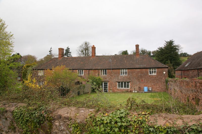
Farmhouse, now divided into flats. C18, perhaps an enlargement of an earlier dwelling. Red sandstone random rubble
double Roman tiled hipped roof, 3 brick stacks. Plan: perhaps an enlargement at a 3 cell and cross passage plan.
2-storeys, 6-bays, first floor early C19 3-light leaded caseaent windows, some with quadrant stays, ground floor, 2
pairs of C20 3-light casement windows with tiled pentices on wooden brackets flanking gabled porch of red sandstone,
tiled roof, elliptical headed opening, C20 plank door.
Listing NGR: ST1099539530
External links are from the relevant listing authority and, where applicable, Wikidata. Wikidata IDs may be related buildings as well as this specific building. If you want to add or update a link, you will need to do so by editing the Wikidata entry.


Other nearby listed buildings
