Approximate Location Map
Large Map »
Latitude: 51.5228 / 51°31'22"N
Longitude: -1.1405 / 1°8'25"W
OS Eastings: 459728
OS Northings: 180781
OS Grid: SU597807
Mapcode National: GBR 920.DGR
Mapcode Global: VHCYW.5ZXH
Plus Code: 9C3WGVF5+4R
Entry Name: Goring Mill
Listing Date: 16 August 1985
Grade: II
Source: Historic England
Source ID: 1059550
English Heritage Legacy ID: 247275
ID on this website: 101059550
Location: Goring, South Oxfordshire, RG8
County: Oxfordshire
District: South Oxfordshire
Civil Parish: Goring-on-Thames
Built-Up Area: Goring
Traditional County: Oxfordshire
Lieutenancy Area (Ceremonial County): Oxfordshire
Church of England Parish: Goring
Church of England Diocese: Oxford
Tagged with: Mill
GORING HIGH STREET
SU5980 (South side)
Goring-on-Thames
11/58 Goring Mill
GV II
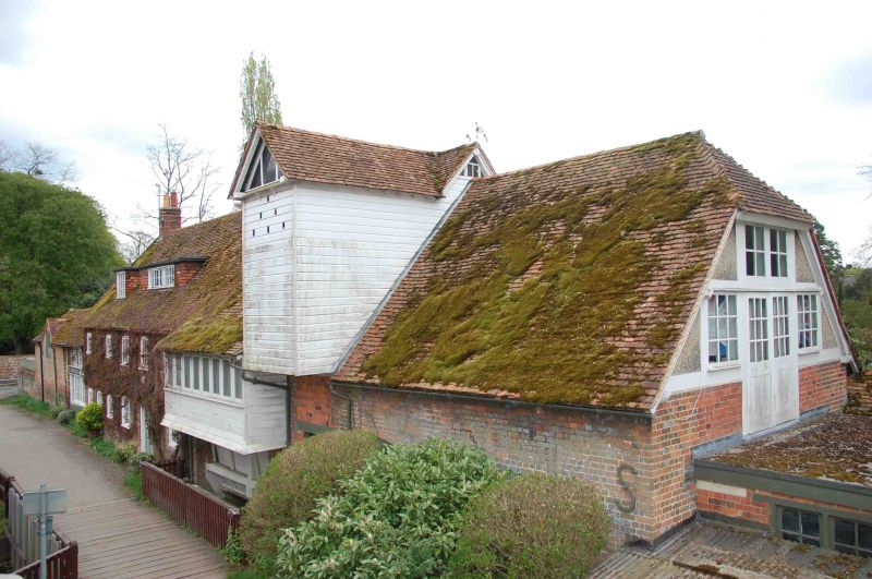
Mill. c18, with C19 alterations. Red brick with grey headers; piain tile roof;
brick end stack to left. 2 storeys and attic; 7-window range. C19 half-glazed
doors to centre, left, and right. Irregular fenestration of casements with
segmental brick heads except C19 casement of 8 lights to first floor right of
centre. Weatherboarded hoist to right of centre with dovecote to cross gable to
top. 2 flat-roofed dormers to left. Double Queen post roof truss to left return.
Interior not inspected. Probably late C18 two storey wing to left with irregular
fenestration.
Listing NGR: SU5972380780
External links are from the relevant listing authority and, where applicable, Wikidata. Wikidata IDs may be related buildings as well as this specific building. If you want to add or update a link, you will need to do so by editing the Wikidata entry.


Other nearby listed buildings
