Approximate Location Map
Large Map »
Latitude: 51.6684 / 51°40'6"N
Longitude: -1.082 / 1°4'55"W
OS Eastings: 463586
OS Northings: 197026
OS Grid: SU635970
Mapcode National: GBR B1N.98K
Mapcode Global: VHCYB.6BCB
Plus Code: 9C3WMW99+96
Entry Name: The Vicarage
Listing Date: 18 July 1963
Last Amended: 3 April 1987
Grade: II
Source: Historic England
Source ID: 1059776
English Heritage Legacy ID: 248891
ID on this website: 101059776
Location: Chalgrove, South Oxfordshire, OX44
County: Oxfordshire
District: South Oxfordshire
Civil Parish: Chalgrove
Built-Up Area: Chalgrove
Traditional County: Oxfordshire
Lieutenancy Area (Ceremonial County): Oxfordshire
Church of England Parish: Chalgrove
Church of England Diocese: Oxford
Tagged with: Clergy house
CHALGROVE HIGH STREET
SU6397 (North side)
9/46 No.97 (The Vicarage)
18/07/63 (Formerly listed as The
Vicarage)
GV II
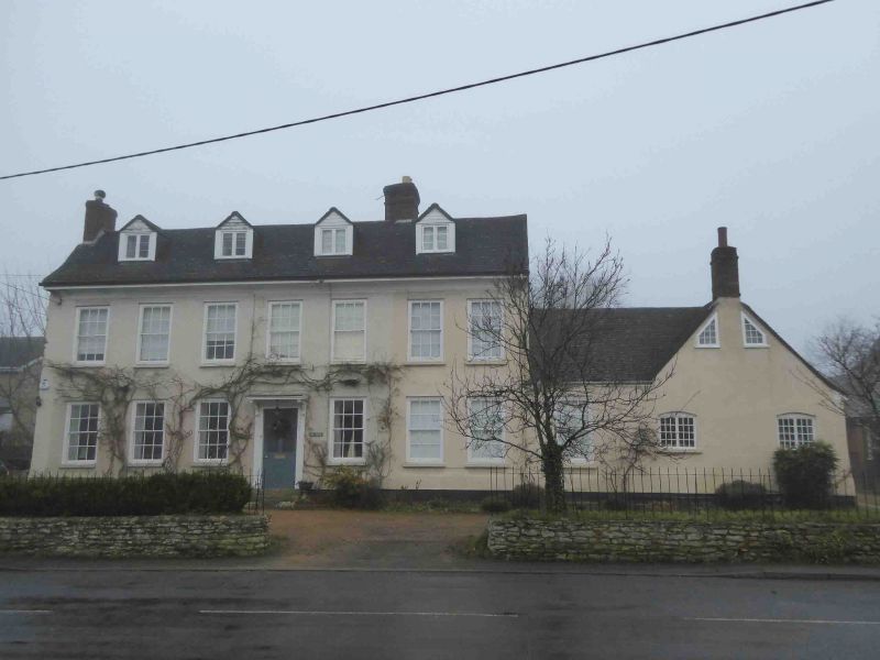
Vicarage, now house. Mid C18. Roughcast; gabled C20 tile roof; brick ridge and
left end stacks. Double-depth plan, 2 storeys and attic; symmetrical 7-window
range. 6-panelled (4 glazed) door with brackets. Late C18 six-pane sashes.
One-storey L-shaped service range to right; of limestone rubble with roughcast
front and end stack. Interior: late C18 shutters. Hall has jewel-stopped
chamfered beam, timber-frame wall to left and 2-bay screen to rear dog-leg
staircase with turned balusters on closed string. Left room has 2 similar beams,
moulded plaster cornice and mid C18 panelling. First-floor inspection not
possible but likely to be of interest.
Listing NGR: SU6358697026
External links are from the relevant listing authority and, where applicable, Wikidata. Wikidata IDs may be related buildings as well as this specific building. If you want to add or update a link, you will need to do so by editing the Wikidata entry.


Other nearby listed buildings
