Latitude: 51.5871 / 51°35'13"N
Longitude: -1.2612 / 1°15'40"W
OS Eastings: 451281
OS Northings: 187838
OS Grid: SU512878
Mapcode National: GBR 7ZQ.KXV
Mapcode Global: VHCYM.3C3P
Plus Code: 9C3WHPPQ+RG
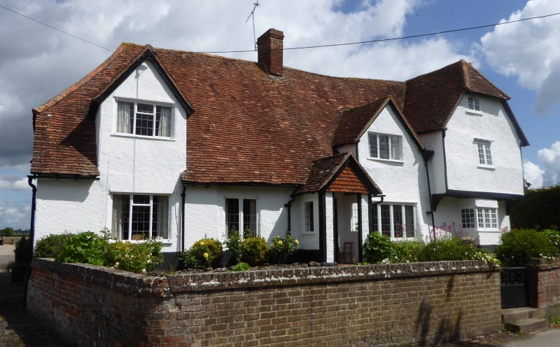
Entry Name: York Farmhouse
Listing Date: 9 April 1952
Last Amended: 4 November 1986
Grade: II
Source: Historic England
Source ID: 1059812
English Heritage Legacy ID: 248777
ID on this website: 101059812
Location: West Hagbourne, South Oxfordshire, OX11
County: Oxfordshire
District: South Oxfordshire
Civil Parish: West Hagbourne
Traditional County: Berkshire
Lieutenancy Area (Ceremonial County): Oxfordshire
Church of England Parish: Hagbourne
Church of England Diocese: Oxford
Tagged with: Farmhouse
WEST HAGBOURNE YORK ROAD SU5187 (North side) 18/164 York Farmhouse 09/04/52 (Formerly listed as York's Farmhouse)
GV II
Farmhouse. Probably early C16 with later alterations. Cruck-framed; rendered base; roughcast, probably on timber-framing; old plain-tile half-hipped roof; brick ridge stack to centre, end stack to right. Hall-house plan with cross-wing to right. Single-storey and attic; 3-window range; with 2-storeys-and-attic cross-wing to right. Plank door to centre with open timber-framed porch. 3-light casement to left. 2-light casement to left of centre. 4-light casement to right of centre. Angled bay to end of cross-wing. Cross-gables with 3-light casements to left and to right of centre. Jettied first floor to cross-wing. 2-light casement to cross-wing first floor centre. Half-hipped gable end to cross-wing with 2-light attic casement. Stone base to left return. Interior: C20 open well staircase. Jointed cruck with arch-bracing to collar to centre. Open fireplace to ground floor right of centre with bread-oven arch. Extensive beaming to interior, spine beans with ogee end-stops.
Listing NGR: SU5128187838
External links are from the relevant listing authority and, where applicable, Wikidata. Wikidata IDs may be related buildings as well as this specific building. If you want to add or update a link, you will need to do so by editing the Wikidata entry.


Other nearby listed buildings