Approximate Location Map
Large Map »
Latitude: 51.1661 / 51°9'57"N
Longitude: 0.5418 / 0°32'30"E
OS Eastings: 577810
OS Northings: 143829
OS Grid: TQ778438
Mapcode National: GBR PSD.ZRH
Mapcode Global: VHJMT.BYSG
Plus Code: 9F325G8R+CP
Entry Name: Coppwilliam
Listing Date: 25 March 1987
Grade: II
Source: Historic England
Source ID: 1060693
English Heritage Legacy ID: 174625
ID on this website: 101060693
Location: Staplehurst, Maidstone, Kent, TN12
County: Kent
District: Maidstone
Civil Parish: Staplehurst
Traditional County: Kent
Lieutenancy Area (Ceremonial County): Kent
Tagged with: Building
STAPLEHURST MARDEN ROAD
TQ 74 SE (North side)
3/156 Coppwilliam
II
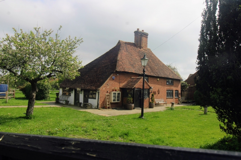
House, formerly cottages, now house. C15, with late C16 or early C17,
C19 and C20 alterations. Timber framed. Front elevation clad with red
brick in Flemish bond. Both floors of right gable end tile-hung.
Plain tile roof. Open hall of 2 unequal-length timber-framed bays, with
storeyed end bay to left. 2 storeys. Former gable end jetty to left.
Steeply-pitched hipped roof with gablets. Filleted brick stack in
front slope of roof towards centre (towards right end of narrow left hall
bay). Slender rear brick stack to left. Irregular fenestration of two
3-light leaded casements. Segmental heads to ground-floor windows.
Ribbed door in brick porch to left end. Blocked doorway, also with
segmental head, and now containing 2-light casement, to right end.
Red brick lean-to to left. Timber-framed rear lean-to. Interior:
exposed framing. Low ceilings. Shaped jowls to principal posts.
Cambered, doubly-chamfered arch-braced tie-beam to central hall truss.
Axial tie-beam to storeyed left end bay. Plain-chamfered axial beam of
heavy scantling to inserted hall floor. Left ground-floor fireplace
with plain brick jambs and chamfered wooden bressumer. Chamfered brick
fireplace with chamfered bressumer to first floor above. Broad
floorboards. Marked on tithe map as Burnt House.
Listing NGR: TQ7781043829
External links are from the relevant listing authority and, where applicable, Wikidata. Wikidata IDs may be related buildings as well as this specific building. If you want to add or update a link, you will need to do so by editing the Wikidata entry.


Other nearby listed buildings
