Approximate Location Map
Large Map »
Latitude: 51.2484 / 51°14'54"N
Longitude: 0.6285 / 0°37'42"E
OS Eastings: 583541
OS Northings: 153193
OS Grid: TQ835531
Mapcode National: GBR QSW.PQF
Mapcode Global: VHJMG.VW3C
Plus Code: 9F326JXH+89
Entry Name: Ruins of Barbicans and Dam at Leeds Castle
Listing Date: 18 December 1985
Grade: I
Source: Historic England
Source ID: 1060933
English Heritage Legacy ID: 174019
ID on this website: 101060933
Location: Ashbank, Maidstone, Kent, ME17
County: Kent
District: Maidstone
Civil Parish: Broomfield and Kingswood
Traditional County: Kent
Lieutenancy Area (Ceremonial County): Kent
Tagged with: Ruins
BROOMFIELD Ruins of Barbicans
TQ 85 SW and Dam at Leeds
2/1 Castle
GV I
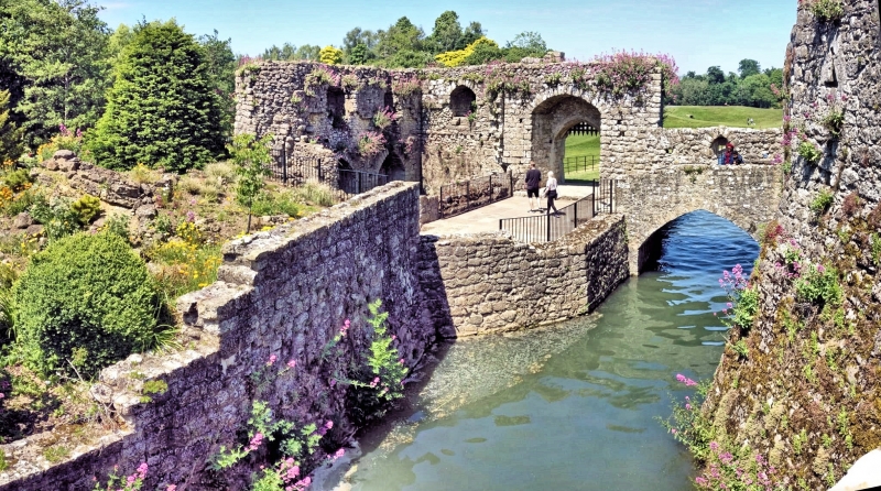
Partly in Leeds civil parish. Triple barbican. Ruins of 2 of
the island barbicans with incorporated mill survive, with dam to
south-east. Probably early-to-mid C13. Mill repaired 1298-9.
Stone. Irregular height. Outer barbican: rectangular, aligned
north-south, with curved south-west corner, and incorporating
ruins of former mill within north-west corner. Connected to dam
by stone wall with small arch. Causeway to north. Pointed
arched stone bridge with parapet, formerly a drawbridge, linking
to inner barbican. Inner barbican: roughly rectangular, parallel
to east of outer barbican, with deep room, possibly a guard room,
immediately to south of bridge. Linked to larger island of
castle to east by stone bridge, formerly a drawbridge, and to
broad causeways to south-east and south-west. South end of
west wall turns south-west to form one wall of south-west
causeway or dam.
Various window openings and loop lights. North gateway to outer
barbican with depressed-pointed arch and portcullis groove. Inner
barbican has similar gateway to bridge between barbicans, and
one jamb of gateway to former south-west bridge and causeway.
See also Leeds Castle [Item 2/2].
Listing NGR: TQ8184352984
External links are from the relevant listing authority and, where applicable, Wikidata. Wikidata IDs may be related buildings as well as this specific building. If you want to add or update a link, you will need to do so by editing the Wikidata entry.


Other nearby listed buildings
