Latitude: 51.318 / 51°19'4"N
Longitude: 0.8921 / 0°53'31"E
OS Eastings: 601630
OS Northings: 161626
OS Grid: TR016616
Mapcode National: GBR SW3.BCL
Mapcode Global: VHKJW.D4ZG
Plus Code: 9F328V9R+5R
Entry Name: 1, Belvedere Road
Listing Date: 3 August 1972
Grade: II
Source: Historic England
Source ID: 1061016
English Heritage Legacy ID: 175858
ID on this website: 101061016
Location: Faversham, Swale, Kent, ME13
County: Kent
District: Swale
Civil Parish: Faversham
Built-Up Area: Faversham
Traditional County: Kent
Lieutenancy Area (Ceremonial County): Kent
Tagged with: Building
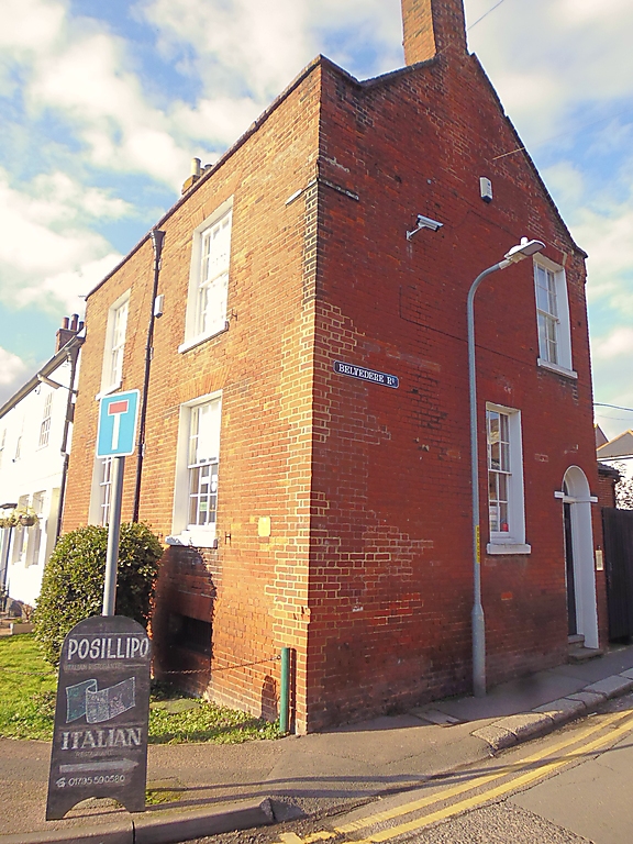
BELVEDERE ROAD
1.
1103 (West Side)
--------------
No 1
Tll 0161 NE 1/206
II GV
2.
Early Cl9. 2 storeys and basement; parapet. 2 windows. Tiled cabled
roof. Red brick front. Windows in reveals with rubbed brick voussoirs;
glazing bars intact.
No 1 forms a group with the Coal Exchange Inn, Quay Lane.
Listing NGR: TR0163061626
External links are from the relevant listing authority and, where applicable, Wikidata. Wikidata IDs may be related buildings as well as this specific building. If you want to add or update a link, you will need to do so by editing the Wikidata entry.


Other nearby listed buildings