Approximate Location Map
Large Map »
Latitude: 52.5614 / 52°33'41"N
Longitude: -0.8383 / 0°50'17"W
OS Eastings: 478847
OS Northings: 296584
OS Grid: SP788965
Mapcode National: GBR BRG.JVD
Mapcode Global: WHFL0.3W27
Plus Code: 9C4XH566+HM
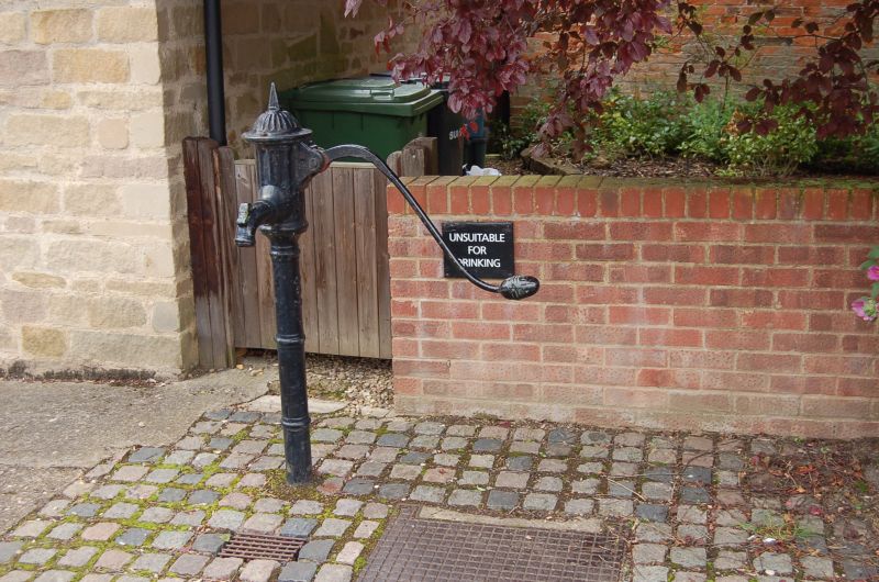
Entry Name: Pump
Listing Date: 13 December 1984
Grade: II
Source: Historic England
Source ID: 1061680
English Heritage Legacy ID: 190840
ID on this website: 101061680
Location: Hallaton, Harborough, Leicestershire, LE16
County: Leicestershire
District: Harborough
Civil Parish: Hallaton
Built-Up Area: Hallaton
Traditional County: Leicestershire
Lieutenancy Area (Ceremonial County): Leicestershire
Church of England Parish: Hallaton St Michael and All Angels
Church of England Diocese: Leicester
Tagged with: Building
SP7896-7996 HALLATON HIGH STREET (West Side)
8/64 Pump
GV II
Pump. Early C19. Cast iron. Banded shaft with fluted cap and spout, and long
curving handle.
Listing NGR: SP7884896583
External links are from the relevant listing authority and, where applicable, Wikidata. Wikidata IDs may be related buildings as well as this specific building. If you want to add or update a link, you will need to do so by editing the Wikidata entry.


Other nearby listed buildings
