Approximate Location Map
Large Map »
Latitude: 52.8495 / 52°50'58"N
Longitude: -0.3485 / 0°20'54"W
OS Eastings: 511310
OS Northings: 329276
OS Grid: TF113292
Mapcode National: GBR GTY.8PQ
Mapcode Global: WHGL0.MM7W
Plus Code: 9C4XRMX2+QH
Entry Name: Group of 6 Table Tombs to West of Church Tower
Listing Date: 22 January 1987
Grade: II
Source: Historic England
Source ID: 1062767
English Heritage Legacy ID: 194254
ID on this website: 101062767
Location: St Andrew's Church, Dowsby, South Kesteven, Lincolnshire, PE10
County: Lincolnshire
District: South Kesteven
Civil Parish: Dowsby
Traditional County: Lincolnshire
Lieutenancy Area (Ceremonial County): Lincolnshire
Church of England Parish: Dowsby St Andrew
Church of England Diocese: Lincoln
Tagged with: Tomb
DOWSBY BOURNE ROAD
TF 12 NW (east side)
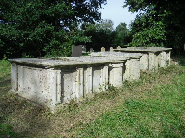
7/40 Group of 6 table
tombs to west of
church tower
G.V. II
6 table tombs. Late C18, early C19. Limestone ashlar. 2 tombs
to right, that to right of Irance Green, died 1787, that to left,
of Sarah Green, died 1781. Both with flat rectangular moulded
tops, panelled sides with narrow projecting, panelled vertical
bands at each corner and moulded bases. 2 tombs to left, that to
right with illegible inscription, that to left of Mary Digby,
died 1792. Both with flat moulded tops with semi-circular ends,
semi-circular east and west panelled sides, that to right with
moulded baluster-type columns at corners; that to left with
fluted pilasters at corners and north side with oval set in
rectangular panel with foliate motifs in each corner and flanked
by single narrow panels containing classical urns, horned sheep
skulls and palms. 2 tombs to left; that to right of Elizabeth
Green, died 1846; that to right of John Green, died 1829. Both
with panelled sides with panelled pilasters at corners. That to
right with a flat moulded top, that to left with gently pointed
top.
Listing NGR: TF1131029276
External links are from the relevant listing authority and, where applicable, Wikidata. Wikidata IDs may be related buildings as well as this specific building. If you want to add or update a link, you will need to do so by editing the Wikidata entry.


Other nearby listed buildings
