Latitude: 53.3663 / 53°21'58"N
Longitude: -0.0074 / 0°0'26"W
OS Eastings: 532680
OS Northings: 387343
OS Grid: TF326873
Mapcode National: GBR XYDH.5Z
Mapcode Global: WHHJS.VNM5
Plus Code: 9C5X9X8V+G2
Entry Name: 10, 10B, 10C and 10D, Upgate
Listing Date: 18 February 1974
Grade: II
Source: Historic England
Source ID: 1063211
English Heritage Legacy ID: 195030
ID on this website: 101063211
Location: Louth, East Lindsey, Lincolnshire, LN11
County: Lincolnshire
District: East Lindsey
Civil Parish: Louth
Built-Up Area: Louth
Traditional County: Lincolnshire
Lieutenancy Area (Ceremonial County): Lincolnshire
Church of England Parish: Louth
Church of England Diocese: Lincoln
Tagged with: Building Apartment building
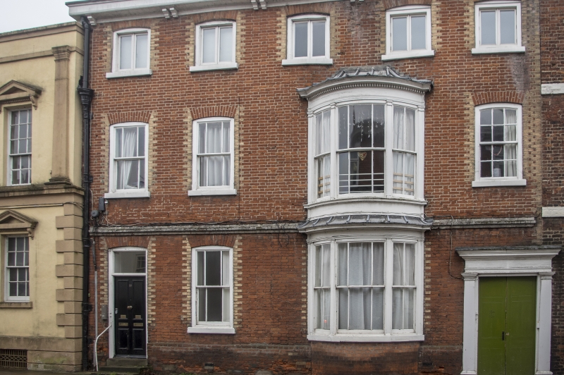
UPGATE 1. 1348 (West Side) No 10 No lOB No 10C No 10D TF 38 NW 1/239 II GV 2. Early C19. One building, now flats. 3 storeys in red brick with yellow dressings. Re-roofed in cement pantiles. Modillion eaves cornice. Tallw plinth. 5 windows, slightly segmental arches, modern casements on top floor. Yellow brick rusticated architraves to windows. 1st floor has 3 windows, segmental arches, 2 with marginal glazing, and 2-storey late C18 bow of 3 lights, marginal glazing, plain pilasters, entablature and dentil cornice, leaded roof. Ground floor has one window, segmental arch, marginal glazing, and 4-panel door in yellow brick architrave, rectangular modern fanlight. 3 steps, modern iron handrail. Double yard doors of 6 panels in plain pilastered painted stucco architrave with entablature and cornice. String between ground and 1st floor. Sole entry to 10B and 1 storey early C19 wing to rear. Nos 6 to 12 (even) form a group.
Listing NGR: TF3268087343
External links are from the relevant listing authority and, where applicable, Wikidata. Wikidata IDs may be related buildings as well as this specific building. If you want to add or update a link, you will need to do so by editing the Wikidata entry.


Other nearby listed buildings