Approximate Location Map
Large Map »
Latitude: 51.381 / 51°22'51"N
Longitude: 0.0181 / 0°1'5"E
OS Eastings: 540539
OS Northings: 166589
OS Grid: TQ405665
Mapcode National: GBR M2.P7N
Mapcode Global: VHHP3.8KF6
Plus Code: 9F3292J9+96
Entry Name: Hayes Farmhouse
Listing Date: 29 June 1973
Grade: II
Source: Historic England
Source ID: 1064366
English Heritage Legacy ID: 358455
ID on this website: 101064366
Location: Hayes, Bromley, London, BR2
County: London
District: Bromley
Electoral Ward/Division: Hayes and Coney Hall
Parish: Non Civil Parish
Built-Up Area: Bromley
Traditional County: Kent
Lieutenancy Area (Ceremonial County): Greater London
Church of England Parish: Hayes St Mary the Virgin
Church of England Diocese: Rochester
Tagged with: Farmhouse
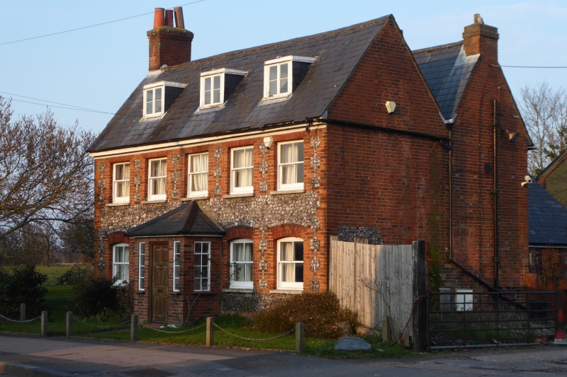
HAYES LANE, HAYES
1.
4407
No 239 (Hayes Farmhouse)
TQ 46 NW 5/49
II
2.
Early C19. 2 storeys and attic. 5 windows. 3 dormers. Faced with knapped
flints with red brick window dressings and quoins. Slate roof. Glazing bars
missing. Door of 6 fielded panels.
Listing NGR: TQ4053966589
External links are from the relevant listing authority and, where applicable, Wikidata. Wikidata IDs may be related buildings as well as this specific building. If you want to add or update a link, you will need to do so by editing the Wikidata entry.


Other nearby listed buildings
