Approximate Location Map
Large Map »
Latitude: 51.7586 / 51°45'30"N
Longitude: -1.2598 / 1°15'35"W
OS Eastings: 451188
OS Northings: 206917
OS Grid: SP511069
Mapcode National: GBR 8YY.LBJ
Mapcode Global: VHCXV.32W5
Plus Code: 9C3WQP5R+C3
Entry Name: 22 and 23, St Giles Street
Listing Date: 12 January 1954
Grade: II
Source: Historic England
Source ID: 1065714
English Heritage Legacy ID: 245826
ID on this website: 101065714
Location: Norham Manor, Oxford, Oxfordshire, OX1
County: Oxfordshire
District: Oxford
Electoral Ward/Division: Carfax
Parish: Non Civil Parish
Built-Up Area: Oxford
Traditional County: Oxfordshire
Lieutenancy Area (Ceremonial County): Oxfordshire
Church of England Parish: Oxford St Giles
Church of England Diocese: Oxford
Tagged with: Building
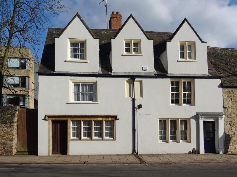
ST GILES' STREET
1.
1485
(East Side)
Nos 22 & 23
SP 5106 NW 5/533 12.1.54.
II GV
2.
RCHM 185. 2 houses. 1 building. Originally early C17 but has been
unsympathetically treated. Now a 2-storeyed stuccoed front of Cl9 (on stone
and timber-framing) a Welsh slate roof and 3 gables. Shop front to No 23;
the ground floor of No 22 has a 3-light sash window in a wood frame. The
lst floor has 1 sash and 1 2-light sash window. In the centre and South
gables are 2-lights casement windows, while in the North gable is a sash
window. The whole has undergone considerable restoration. Interior RCHM
p 179 a. Includes some reset panelling of early date and some of C18.
Nos 1, 11 to 17 (consec), l9, 20, B1ack Hall, Part of Queen Elizabeth House
and Nos 22 and 23 form a group.
Listing NGR: SP5119706967
External links are from the relevant listing authority and, where applicable, Wikidata. Wikidata IDs may be related buildings as well as this specific building. If you want to add or update a link, you will need to do so by editing the Wikidata entry.


Other nearby listed buildings
