Latitude: 51.5183 / 51°31'5"N
Longitude: -0.1348 / 0°8'5"W
OS Eastings: 529510
OS Northings: 181578
OS Grid: TQ295815
Mapcode National: GBR F9.WX
Mapcode Global: VHGQZ.M32F
Plus Code: 9C3XGV98+83
Entry Name: 11 and 13, Charlotte Street W1
Listing Date: 1 December 1987
Grade: II
Source: Historic England
Source ID: 1066260
English Heritage Legacy ID: 209128
ID on this website: 101066260
Location: Fitzrovia, Westminster, London, W1T
County: London
District: City of Westminster
Electoral Ward/Division: West End
Parish: Non Civil Parish
Built-Up Area: City of Westminster
Traditional County: Middlesex
Lieutenancy Area (Ceremonial County): Greater London
Church of England Parish: St Giles-in-the-Fields
Church of England Diocese: London
Tagged with: Building
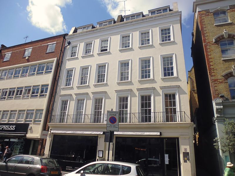
CITY OF WESTMINSTER CHARLOTTE STREET, Wl TQ 2981 NE 47/2 Nos. 11 and 13 II Pair of terrace houses with shops. c.1830. Stucco faced, slate roofs. 4 storeys and renewed dormered mansard. Each 3 windows wide. Ground floor has large double former shop fronts carried across, probably a late C19 alteration with broad flanking pilasters and continuous fascia with dentil cornice. To the right flank in Percy Passage the earlier C19 frame of shop front remains with gorged end stops to fascia with row of rosettes and dentil cornice, blocked openings beyond with rosettes in entablatures. The upper floors of front have recessed glazing bar sashes, all in architraves, those on 1st floor with cornices and consoles to sills on floors above. Continuous 1st floor cast iron flat patterned baluster balcony; crowning cornice and blocking course.
Listing NGR: TQ2951081578
External links are from the relevant listing authority and, where applicable, Wikidata. Wikidata IDs may be related buildings as well as this specific building. If you want to add or update a link, you will need to do so by editing the Wikidata entry.


Other nearby listed buildings