Approximate Location Map
Large Map »
Latitude: 51.5133 / 51°30'47"N
Longitude: -0.1389 / 0°8'19"W
OS Eastings: 529242
OS Northings: 181020
OS Grid: TQ292810
Mapcode National: GBR DC.ZP
Mapcode Global: VHGQZ.J7Y6
Plus Code: 9C3XGV76+8C
Entry Name: 24, Carnaby Street W1
Listing Date: 23 November 1978
Grade: II
Source: Historic England
Source ID: 1066326
English Heritage Legacy ID: 209003
ID on this website: 101066326
Location: Soho, Westminster, London, W1F
County: London
District: City of Westminster
Electoral Ward/Division: West End
Parish: Non Civil Parish
Built-Up Area: City of Westminster
Traditional County: Middlesex
Lieutenancy Area (Ceremonial County): Greater London
Church of England Parish: St Anne Soho
Church of England Diocese: London
Tagged with: Building
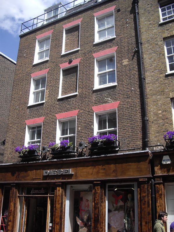
TQ 2981 SW CITY OF WESTMINSTER CARNABY STREET, W1
57/73
23.11.78 No. 24
GV II
Terrace house on corner site. c.1820. Stock brick, slate roof. 4 storeys and
dormered mansard. 2 windows wide. Double wooden shop front to both fronts, doorway and display windows mid C20 but retaining part of consoled pilaster frame and entablature with moulded cornice. Upper floors have recessed sashes, no glazing bars, under flat, gauged red brick arches. Parapet with coping. Part of the c.1820 redevelopment of Carnaby Street and Newburgh Street.
Survey of London; Vol. XXXl.
Listing NGR: TQ2924281019
External links are from the relevant listing authority and, where applicable, Wikidata. Wikidata IDs may be related buildings as well as this specific building. If you want to add or update a link, you will need to do so by editing the Wikidata entry.


Other nearby listed buildings
