Latitude: 53.5151 / 53°30'54"N
Longitude: -2.4001 / 2°24'0"W
OS Eastings: 373568
OS Northings: 402120
OS Grid: SD735021
Mapcode National: GBR CWPS.5N
Mapcode Global: WH982.3XC4
Plus Code: 9C5VGH8X+2X
Entry Name: Parrfold Farmhouse
Listing Date: 2 September 1987
Grade: II
Source: Historic England
Source ID: 1067487
English Heritage Legacy ID: 211992
ID on this website: 101067487
Location: Parr Fold, Salford, Greater Manchester, M28
County: Salford
Electoral Ward/Division: Walkden South
Parish: Non Civil Parish
Built-Up Area: Walkden
Traditional County: Lancashire
Lieutenancy Area (Ceremonial County): Greater Manchester
Church of England Parish: Worsley St Mark
Church of England Diocese: Manchester
Tagged with: Farmhouse
WORSLEY BROADWAY SD 70 SW (west side) 1/34 ParrFold Farmhouse - Parr Fold G.V. II
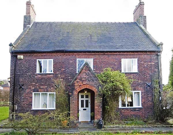
House. C17 or early C18 but with rebuilding and additions dated 1853. English garden wall bond brick with clay tile roof. 3-bay 2-storey plan with central entrance and additions to rear. Remnants of stone quoins to left. Brickwork of various dates but including narrow bricks probably of the C17. Central door with flat brick arch obscured by gabled porch of 1853 with Tudor-arched opening. Englarged window openings to either side. 3 first floor windows with cambered brick arches and C20 casements. Steep roof with coped gable and kneelers. Projecting gable chimney stacks of C19 date with blue header diaper pattern. Wing to rear with datestone "BT 1853" has various C20 casement windows some in original openings and a door with brick hoodmould.
Listing NGR: SD7356802120
External links are from the relevant listing authority and, where applicable, Wikidata. Wikidata IDs may be related buildings as well as this specific building. If you want to add or update a link, you will need to do so by editing the Wikidata entry.


Other nearby listed buildings