Approximate Location Map
Large Map »
Latitude: 53.4421 / 53°26'31"N
Longitude: -2.3839 / 2°23'1"W
OS Eastings: 374598
OS Northings: 393998
OS Grid: SJ745939
Mapcode National: GBR CXSM.PT
Mapcode Global: WH98G.CR21
Plus Code: 9C5VCJR8+VF
Entry Name: Larkrise
Listing Date: 29 June 1966
Grade: II
Source: Historic England
Source ID: 1067880
English Heritage Legacy ID: 213001
ID on this website: 101067880
Location: Flixton, Trafford, Greater Manchester, M41
County: Trafford
Electoral Ward/Division: Flixton
Parish: Non Civil Parish
Built-Up Area: Urmston
Traditional County: Lancashire
Lieutenancy Area (Ceremonial County): Greater Manchester
Church of England Parish: Flixton St Michael
Church of England Diocese: Manchester
Tagged with: Building
In the entry for
URMSTON THE VILLAGE
(South side)
4/37
Nos 18 and 20
(Larkrise)
The address shall be
amended to read URMSTON THE VILLAGE
(Flixton) (South side)
Nos 18 and n20
(Larkrise)
------------------------------------
URMSTON THE VILLAGE
SJ 79 SW
(SJ 7494 SE) (south side)
4/37 Nos 18 and 20
29/6/66 (Larkrise)
GV II
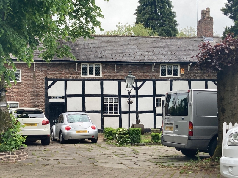
House. "IFW1672" carved on timber rail but with brick additions of late C18.
2-bay timber-framed structure on stone plinth with brick additions to left, right
and above. Slate roof. The timber-framed structure is 3 square panels in height
with diagonal braces to the principal posts. Original studded oak door to left
and later door inserted to right. Later 3-light windows. 1-bay Flemish bond
brick addition to left and right with cambered brick arches over replaced casement
windows. The eaves were also raised in brick and incorporate 2 casement windows.
Ridge chimney stacks. Similar rear elevation which has had some of the timber
members replaced or rendered over. Interior: door opens onto inglenook fireplace
with chamfered curved bressumer beam and a wattle and daub heck with chamfered
heck post. Chamfered floor beams some of which are C20 replacement. Tie-beam
roof trusses with inclined struts.
Listing NGR: SJ7459893998
External links are from the relevant listing authority and, where applicable, Wikidata. Wikidata IDs may be related buildings as well as this specific building. If you want to add or update a link, you will need to do so by editing the Wikidata entry.


Other nearby listed buildings
